4.4 The units of the sea
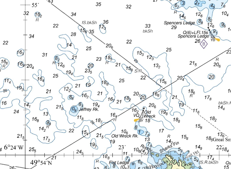
Distances on the sea are measured in nautical miles. One nautical mile is defined as one minute of latitude. This means that, as well as the chart scale, the latitude scale on the chart can be used measure distance. For example, on the example chart below, the distance from the Old Wreck buoy to Spencers Ledge Buoy is about 0.7 nautical miles.
Never use the longitude scale to measure distance. A glance at a diagram showing lines of longitude shows that they converge at the poles. So a minute of longitude varies from about 1,855 m at the equator to zero at the poles. This makes the longitude scale useless for measuring distance.
How far is it from the Old Wreck Buoy to Jeffrey Rock? I measure the distance on my screen with a ruler as 42 mm - your measurement may differ, by the important thing is that this is about 4 and a half ticks up the latitude (vertical) scale on the map. 10 ticks up this scale is 1 minute of latitude, or 1 nautical mile. So, the distance is 4.5/10 = 0.45 nautical miles.
4.4.1 Distances and speeds
One nautical mile is approximately two kilometers and is very close to one statute mile. Kilometers are a more natural unit to use on OS maps with 1 km squares, but it helps to think of 2 squares as a nautical mile. As a rough guide, a novice group might want to cover 4-6 miles in a day, whereas a regular paddler might aim for 10-12 miles, or perhaps 20 if they’re fit and keen.
A boat that moves 1 nautical mile in one hour is said to have a speed of 1 knot. This would be rather slow. An inexperienced group of paddlers might expect to move at 2 knots, whilst a small experienced group might cruise at 3 knots. A fast and fit paddler might be able to cruise at 4 knots and sprint at 5 knots for a short period.