4.3 Latitude and longitude
Nautical charts are designed for use by vessels that might voyage across much of the globe. The OS grid only covers the British Isles, so a more universal system is needed to give positions anywhere in the world. Positions on nautical charts are given as latitude and longitude. It will help to understand how this system works on a global scale before using it to define a position.
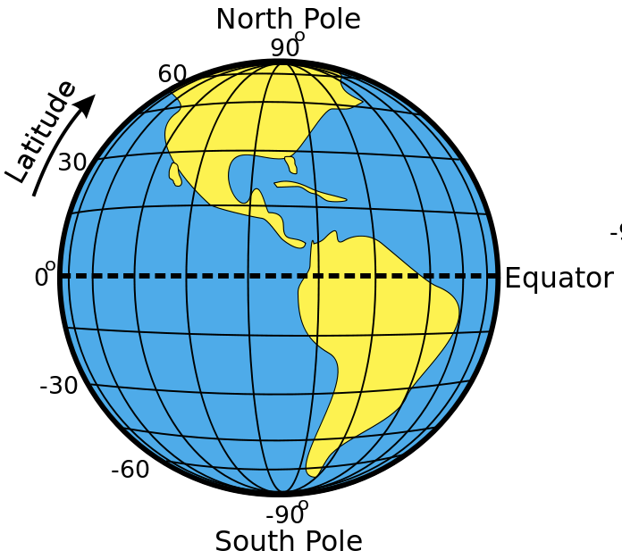
The earth can be conceived of as a sphere, rotating about the poles, with a line called the equator halfway between the poles. Latitude and longitude are angles measured from the center of the earth. The equator is defined as the line of zero latitude. The north pole is defined as latitude 90 degrees north and the south pole as latitude 90 degrees south. Lines of latitude run around the earth parallel to the equator and are defined by the angle between the line, the center of the earth and the equator.
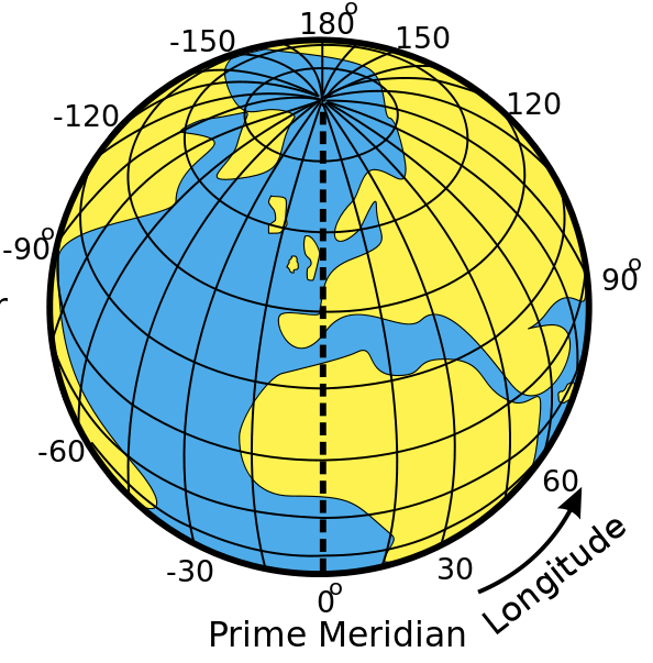
By contrast, lines of longitude run from the North Pole to the South Pole. There is no natural line of zero longitude, but by convention, Greenwich is defined as longitude zero. Points to the west of Greenwich have a westerly longitude (e.g. 30˚W) and points the east have an easterly longitude (e.g. 10˚E). G
One degree of latitude or longitude is quite a large distance, so subdivisions are required to specify position precisely. Each degree is divided into 60 minutes. A minute is denoted by a single quote mark: 1’. So, longitude 10˚ 30’ W is halfway between 10˚W and 11˚W.
Each minute can be subdivided again into 60 seconds (60”), but in practice, decimal minutes are more commonly used. So a longitude might be given as 4˚39.6’W.
Again, an example is the easiest way to explain how latitude and longitude are used in practice.
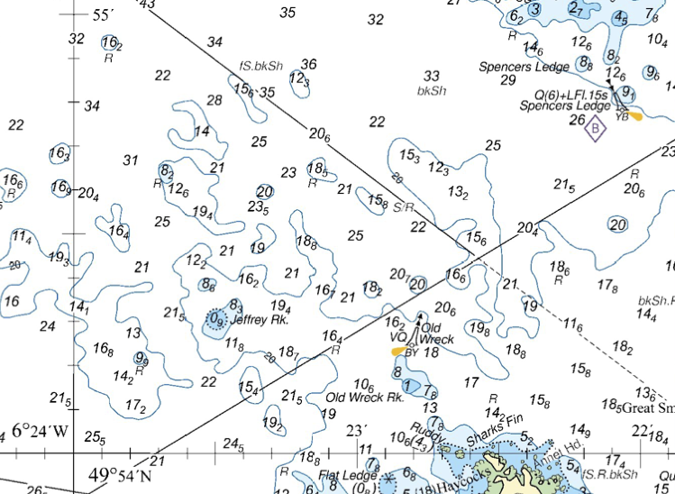
What is the position of the Old Wreck buoy?
Latitude will be shown vertically up the chart, along scales on the sides and on some grid lines. We can see that latitude 49˚54’N is shown in full, and 49˚55’N is indicated by a 55’ mark. Between these, there are 10 divisions, so each must be 0.1 of a minute. The latitude of the buoy is 49˚54.2’N
Longitude is shown similarly horizontally across the charts. Note that because this chart is of an area west of Greenwich, the numbers increase from right to left. We can see 6˚24’W marked in full, with 23’ and 22’ also shown. The longitude of the buoy is 6˚22.8’W.
The position can be specified as 49˚54.2’N 06˚22.8’W (we’ve included a zero ahead of the 6˚ just to make it clear there’s not a number missing).
We’d say this (e.g. over VHF) as “four-nine degrees, five four decimal 2 minutes north, zero-six degrees, two two decimal eight minutes west”.
Note that, in contrast to grid references, the northerly coordinate is given first. Directions (north, south, east or west) are always included.
Chart © Crown Copyright and/or database rights. NOT FOR NAVIGATION. Reproduced by permission of the Controller of Her Majesty’s Stationery Office and the UK Hydrographic Office (www.GOV.uk/UKHO)