2.9 Pilots and guidebooks
Tidal diamonds and detailed tidal atlases are not available for all areas. Often, we must rely on less complete data given in narrative form from local experts. Such data can be found in sailing directions, books that are written to convey local knowledge to mariners. These are colloquially know as ‘pilots’. The UKHO publishes a range of pilots covering the UK in detail and the rest of the world in less detail. Other national agencies do the same. The information in these pilots is primarily intended for large ships, so yachtsman have produced their own pilots, often with more detailed information, for areas in which they cruise. These are often useful for kayakers.
Sea kayaking guidebooks include the most important tidal information from pilots and other sources. Being focused on kayaks, rather than large ships or yachts, they’re a great source of information in a compact format. Over the last few year, Pesda Press has published an excellent set of guidebooks covering most of the UK. For most kayakers, these books will be cheaper, more accessible and better than UKHO or yachting pilots.
All pilots use a similar format for describing tidal streams. In sea kayak pilots you will also see tidal stream data shown graphically on maps:
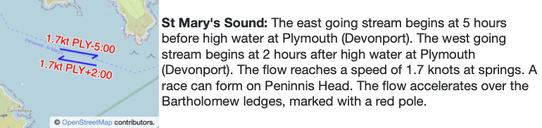
Pilot information is presented in a fairly understandable format. Its use is best illustrated by an example.
Describe the tidal flow in Saint Mary’s Sound on June 14th 2017 (HW Plymouth is at 09:29 BST and 21:44 BST)?
We already know that HW Plymouth is at 09:29 BST and 21:44 BST.
The ESE stream begins HW Plymouth -5:00
09:29 – 05:00 = 04:29 BST
21:44 – 05:00 = 16:44 BST


The WNW stream begins HW Plymouth +2:00
09:29 + 02:00 = 11:29 BST
21:44 + 02:00 = 23:44 BST
So, we expect the tide to run ESE in the morning (from 04:29), turning WNW at 11:29. It turns ESE again at 16:44, running in this direction until 23:44.