4.7 Specifying position
It is useful to be able to specify a position exactly on a map or chart. Indeed, this could be of critical importance when informing the coastguard of your whereabouts in an emergency.
4.7.1 Grid references
Many people will be aware of the OS national grid. All OS maps are overlaid with blue grid lines which divide the map into 1 km squares. Numbers along the side of the map allow each square to be referenced.
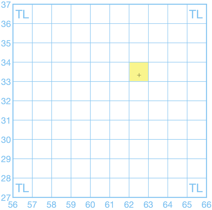
To reference a specific square on the grid we use the numbers to the left of and below the square. For example, to reference the square on the grid above highlighted in yellow, we’d use the number 62 along the bottom of the map (the ‘easting’) and 33 along the side (the ‘northing’). OS grid references are always given with the number along the bottom of the map (easting) first (some people use the phrase ‘bottoms up’ to remember this). So the grid reference for the square is ‘62 33’.
The reference numbers on OS maps only go from 00 to 99. This is a problem as OS maps have to cover the whole country, which is larger than 100 km x 100 km! To solve this problem the country is divided up into 100 km squares, each referenced by 2 letters. You’ll find these letters at the corners of OS maps, or at the edges of the squares, when these appear on a map. Our grid above is entirely in the ‘TL’ 100 km square, so we can provide a gird reference for our square of ‘TL 62 33’. In practice, the letters can be omitted if it’s clear roughly where the location is.
TL 62 33 is called a 4-figure grid reference for fairly obvious reasons. 4 figure grid references refer to a 1 km square, which is quite a large area. We often want to specify location more accurately than that. Because of this, sea kayakers will normally use 6-figure grid references, which specify a 100m x 100m square.
You’ll notice that there aren’t any grid lines spaced at 100 m intervals - they’d make the map look very cluttered. We need to estimate location within the grid square instead. For example, let’s create a 6-figure gird reference for the cross on the grid above. Looking first at the eastings along the bottom of the map, the cross appears about halfway across the grid square. Thinking of 10 imaginary divisions across the grid square, the cross would be on the 5th division, so we append the number ‘5’ to our original easting number to give ‘625’. Looking up the side of the map, we estimate that the cross is about three tenths of the way up the grid square, giving a northing of 333. Our complete 6-figure grid reference is ‘TL 625 333’.
Let’s look at an example on a real map.
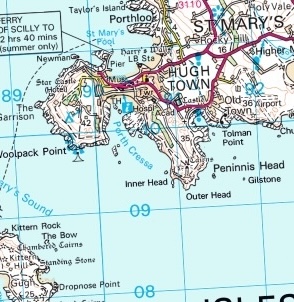
What is the grid reference of the Peninnis Head lighthouse?
Notice that we can’t see the edge of the map here. However, you’ll notice that grid numbers are helpfully printed across the map to make giving grid references easier.
- Two letters that identify the 100 km square – in this case ‘SV’. This would be given on the corners of the map sheet (not shown on the map extract above).
- The ‘easting’ – the ‘horizontal’ coordinate. We use the scale on the edge of the map, which is repeated for convenience across the sheet. The first two letters identify the grid square – in this case ‘91’. For greater precision, we can add a third number to indicate how many tenths across the square the location is. In this case the lighthouse is 1/10 of the way across the square, so the third number is ‘1’ to give a complete easting of ‘911’
- The ‘northing’ – the ‘vertical’ coordinate. Exactly the same as for the easting, but up the map. In this case, ‘093’. Note that we keep the leading zero here to make it clear that this is a 6 figure gird reference, and we aren’t referring to square 93.
The complete grid reference is thus ‘SV 911 093’.
We’d use the phonetic alphabet to say this over VHF: “Sierra Victor nine-one-one zero-nine-three”.
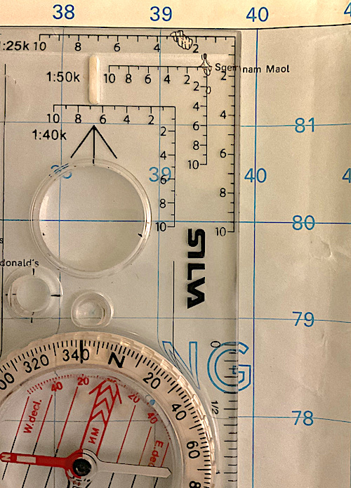
Giving 6-figure grid references is somewhat approximate, but for most purposes estimating the final numbers for eastings and northings by eye is good enough. A tool called a ‘romer’ - a card with graduations matched to the map scale - can be used to improve accuracy. Many hiking compasses feature romer scales at their corners, so if you’re carrying a compass, it’s likely that you can use one if you want to be super-accurate.
There’s no theoretical reason to stop at 6 figures. An 8-figure grid reference specifies position to the nearest 10 meters. It’s hard to read an 8-figure grid reference from a map (although using a romer and a 1:25,000 makes it feasible). However, 8-figure (or even 10-figure) grid references are commonly given by GPS units.
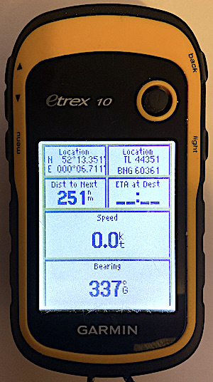
If you end up faced with an abnormally long OS grid reference, simply ignore anything after the first 3 figures of the northing and easting to give yourself an understandable 6-figure gird reference. For example, the GPS unit in the photo above shows ‘TL 44351 60361’. I’ll read off TL 443 603, which is a 6-figure grid reference that I can reference to a map easily.
4.7.2 Latitude and longitude*
Nautical charts are designed for use by vessels that might voyage across much of the globe. The OS grid only covers the British Isles, so a more universal system is needed to give positions anywhere in the world. Positions on nautical charts are given as latitude and longitude. It will help to understand how this system works on a global scale before using it to define a position.
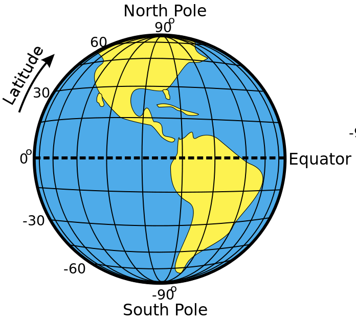
The earth can be conceived of as a sphere, rotating about the poles, with a line called the equator halfway between the poles. Latitude and longitude are angles measured from the center of the earth. The equator is defined as the line of zero latitude. The north pole is defined as latitude 90 degrees north and the south pole as latitude 90 degrees south. Lines of latitude run around the earth parallel to the equator and are defined by the angle between the line, the center of the earth and the equator.
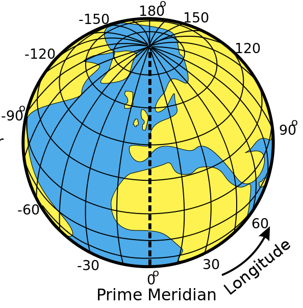
By contrast, lines of longitude run from the North Pole to the South Pole. There is no natural line of zero longitude, but by convention, Greenwich is defined as longitude zero. Points to the west of Greenwich have a westerly longitude (e.g. 30˚W) and points the east have an easterly longitude (e.g. 10˚E). G
One degree of latitude or longitude is quite a large distance, so subdivisions are required to specify position precisely. Each degree is divided into 60 minutes. A minute is denoted by a single quote mark: 1’. So, longitude 10˚ 30’ W is halfway between 10˚W and 11˚W.
Each minute can be subdivided again into 60 seconds (60”), but in practice, decimal minutes are more commonly used. So a longitude might be given as 4˚39.6’W.
Again, an example is the easiest way to explain how latitude and longitude are used in practice.
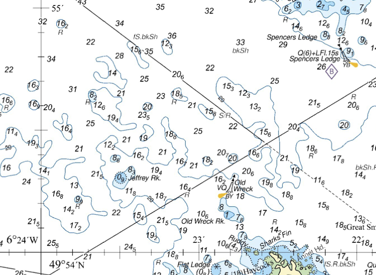
What is the position of the Old Wreck buoy?
Latitude will be shown vertically up the chart, along scales on the sides and on some grid lines. We can see that latitude 49˚54’N is shown in full, and 49˚55’N is indicated by a 55’ mark. Between these, there are 10 divisions, so each must be 0.1 of a minute. The latitude of the buoy is 49˚54.2’N
Longitude is shown similarly horizontally across the charts. Note that because this chart is of an area west of Greenwich, the numbers increase from right to left. We can see 6˚24’W marked in full, with 23’ and 22’ also shown. The longitude of the buoy is 6˚22.8’W.
The position can be specified as 49˚54.2’N 06˚22.8’W (we’ve included a zero ahead of the 6˚ just to make it clear there’s not a number missing).
We’d say this (e.g. over VHF) as “four-nine degrees, five four decimal 2 minutes north, zero-six degrees, two two decimal eight minutes west”.
Note that, in contrast to grid references, the northerly coordinate is given first. Directions (north, south, east or west) are always included.
Chart © Crown Copyright and/or database rights. NOT FOR NAVIGATION. Reproduced by permission of the Controller of Her Majesty’s Stationery Office and the UK Hydrographic Office (www.GOV.uk/UKHO)