1.1 Weather forecasts
1.1.1 Sources of forecasts
The main things to know about the weather are where to find a good forecast and how to interpret it.
Unsurprisingly, the internet is a great source of weather information. Good sites include:
- https://www.metoffice.gov.uk - the ‘official’ forecasts for the UK, including marine forecasts
- http://magicseaweed.com - designed for surfers, but gives usable wind and wave information
- https://www.windy.com - my current favorite site
- https://www.windfinder.com - usable interface and a good phone app
- http://marine.meteoconsult.co.uk/marine-weather-forecast/weather-forecast-coastline.php
- https://www.windguru.cz
Most of these forecasts will give the following information:
- Wind speed - see notes on wind below.
- Wind direction - typically given as the direction that the wind will blow from. However, many forecasts will provide an arrow in the direction that the wind is blowing to. Useful to know, as we can plan paddles that start by going upwind to give us an easy homeward leg, or we can choose to find shelter behind the land (but beware the dangers of an offshore wind).
- Wave height - can our group cope with the forecast waves? What effect will they have when they strike the coast? Waves of 1 meter will feel serious to an inexperienced group. This is about the height when group members will sometimes disappear in the troughs.
- Wave period - long period swell is easier to paddle in than short period chop. However, long period swell implies a bigger wave for a given height, so the effect of the wave breaking will be more powerful.
- Wave direction - suggests where we can find shelter.
- Temperature - Clearly, the risks of hypothermia increase if it’s colder. However, the water temperature may be as big a factor as the air temperature. The water temperature varies little day to day, but does change through the year, being lowest around January to March and highest around August. Dressing for the conditions, and dressing for immersion, can mitigate this risk - but may not be an option for those who don’t yet own dry suits.
- Precipitation - (rain, snow etc.) - how miserable or pleasant will the day be? Heavy and persistent rain can make a group colder (and more miserable!) if not dressed for the conditions.
- Visibility - might it be misty or foggy, making it hard to navigate or see other craft on the water?
- Outlook - will it be sunny or cloudy?
Some weather forecast sources have more information than others and they present information in different ways. Try a few different ones to see what works for you.
It is useful to look at weather forecasts for the periods before and after our planned paddle:
Windy conditions before the time we’re on the water can generate waves that persist. And it’s possible that the timing of any weather changes isn’t forecast precisely.
It’s useful to be aware of any forecast changes later in the day - these might occur earlier than forecast, and, of course, it’s possible that the paddle takes longer than we expect.
1.1.2 Understanding forecasts
It’s important to understand what the forecasts mean. Often, the settings on a weather app or site can be changed to make this easier - for example, you might prefer the temperature in Centigrade or Fahrenheit, or you might want the wind speed in knots or on the Beaufort Scale.
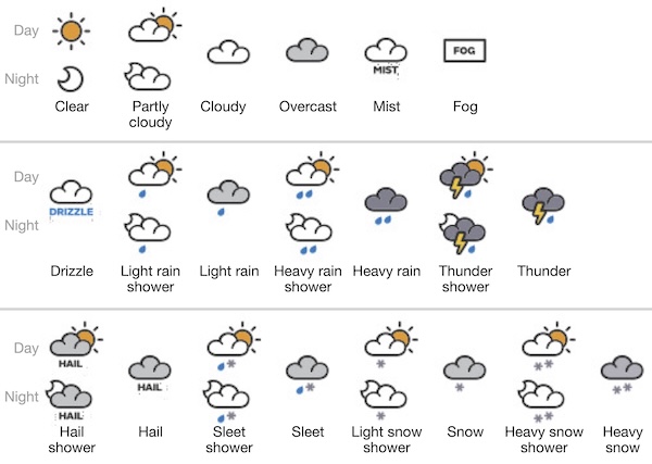
Many forecasts use symbols to describe the weather. These will vary a little between forecasts (so check!), but they’re likely to be similar to those used by the UK Met Office, shown below
Some forecasts will give a probability for rain (e.g. 60%). On a Met Office forecast this gives the chance that at least 0.1mm/hour of rain will fall during the 1 or 3 hour period being forecast.