2.2 Tide tables
The tide at ports is of significant interest to mariners and data exists on the height of tide going back many years. For example, data at https://www.bodc.ac.uk gives records of the tide at Newlyn in Cornwall going back to 1915. This data enables very accurate forecasts to be made of the times of high and low water at these locations, known as ‘standard ports’. Times of high and low water for standard ports are given in tide tables.
Tide tables are easy to use, but often report times in Greenwich Mean Time (GMT). During summer, when British Summer Time (BST) is in operation, an hour needs to be added to give the correct time. Some tide tables are given with the corrections for BST already applied - so always check if you’re using an unfamiliar tide table!
Tide tables are available from many sources. I find that the most useful are:
- The National Tide and Sea Level Facility: Accurate data for all major UK ports for the next 28 days.
- Easytide: UKHO site giving predictions 7 days ahead for practically anywhere in the world.
- Visit My Harbour: An impressive array of free tide tables for the whole of the current year.
Tide tables can, of course, be purchased in printed form. They also appear in nautical almanacs that are republished each year. I find it useful to obtain a copy of Reeds Small Craft Almanac each year so that I’m not reliant on an internet connection when I’m doing tidal planning.
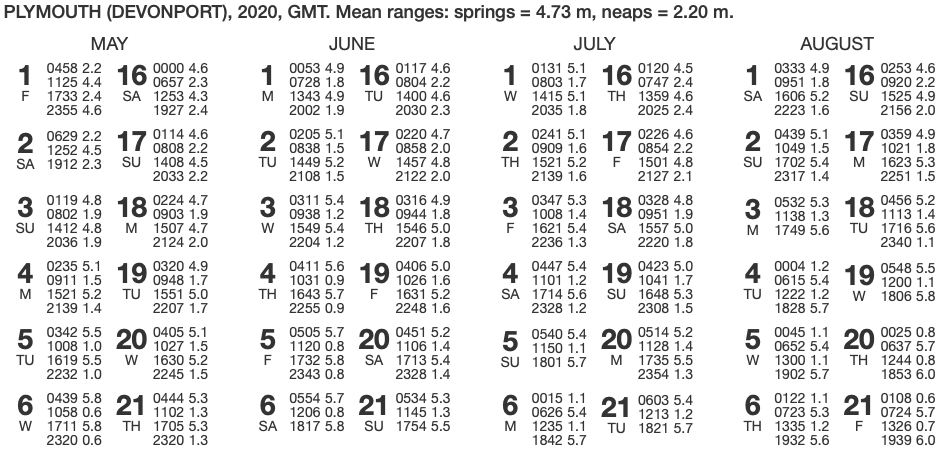
Find times of high and low water during the day at Plymouth on June 4th 2020. Also, find the tidal range.
Consult the tide table for Plymouth above. Note that times are given in GMT. Find the entry for June 4.
Big values of tidal height (5.6 m, 5.7 m) must refer to high water (HW). Low values (0.9, 0.9) refer to low water. So, during the day, the times are:
10:31 GMT   0.9 m Low water
16:43 GMT   5.7 m   High water
(we’re ignoring the early morning high tide and the late night low tide)
Being June, British Summer Time (BST) is in operation. To convert to BST, we must add one hour to the times given:
11:31 BST   0.9 m Low water
17:43 BST   5.7 m   High water
The tidal range is the difference in height of tide between high and low water: 5.7 - 0.9 = 4.8 m.
To plan paddles in areas affected by tides, we’ll likely need additional information not in tide tables - for example from guide books, charts and nautical almanacs. We’ll look at how to use this information in subsequent sections of these notes.
2.2.1 Tidal range
The tidal range is simply the difference in the height of the tide between high water and low water. Some parts of the world have a small tidal range - like the South Devon and Dorset coasts (up to 3m), whilst others have large ranges, like the Bristol channel (up to 14.4 m). In general, you’ll need to pay more attention to planning for the tides in areas with larger tidal ranges.
It is often useful to know whether the tide is a spring tide, a neap tide or somewhere in between.
Simply inspecting the tide table can give some information - spring tides will be associated with higher high waters and lower low waters. Some tide tables will indicate the days on which spring or neap tides occur.
2.2.2 Tidal factor*
I find it useful to calculate a tidal factor – the ratio of today’s tidal range to the typical tidal range for a spring tide. This will be 1 (or 100%) for a typical spring tide and about 0.5 (or 50%) for a typical neap tide. Calculating this is straightforward, but a calculator can be handy:
Factor = tidal range today / tidal range at mean springs
For example, if the tidal range today is 6 meters and the tidal range at mean springs is 8.3 meters, then the factor is 6/8.3 = 0.72 = 72%
Data on the tidal ranges at mean springs can be found:
- In the back of Pesda Press’s sea kayak guidebooks.
- At https://www.ntslf.org (under ’highest & lowest predicted tides) - you’ll need to subtract mean low water springs from mean high water springs to get the mean spring range
- In any nautical almanac (e.g. The Reeds Small Craft Almanac)
For example, the mean tidal ranges at springs and neaps are given at the top of the tide table below:
What is the tidal factor on June 1st 2020?
On June 1st, we have the following tidal data for Plymouth (adding an hour for BST):
08:28 BST Low water 1.8 metres
14:43 BST High water 4.9 metres
The tidal range on July 4th is 4.9-1.8 = 3.1 metres.
The mean range at springs for Plymouth is 4.73 metres. So the tidal factor is 3.1/4.73 = 0.66 = 66%.
The tidal factor is 66%, which is part way between neaps (50%) and spring (100%), but closer to neaps than springs.