1.7 Maritime forecasts
It is useful to be able to interpret the inshore waters forecast issued by the met office. This is available:
- on the Met office website, currently here
- on Radio 4 at 00:48 and 05:20 (long wave and FM) 12:01 and 17:54 (normally long wave only)
- over VHF radio at regular intervals
It is issued for times a day at 00:00 (midnight), 06:00, 12:00 and 18:00 UTC for the subsequent 24 hours.
The forecast includes gales warnings then the general situation for the UK, followed by the area forecasts. Each area forecast contains the following elements, in order:
- Wind strength (Beaufort scale) and direction -e.g. “West 4 or 5, backing southwest 5 or 6 later.”
- Sea state - e.g. “Slight or moderate.” See below.
- Weather - e.g. “Occasional rain later.”
- Visibility - e.g. “Good.”
The forecast contains a lot of information, and it can be read out very quickly. It’s worth having a pen and paper to hand to note down the forecast that you need. I sometimes write the forecast onto the deck of my boat using a grease pencil if I hear it whilst I’m on the water.
Some of the terms used in the forecast are explained in more detail below.
Timing - the words used have precise meanings:
- Imminent: within 6 hours
- Soon: 6-12 hours
- Later: >12 hours
Sea state - innocuous sounding sea states can cause problems for kayakers:
- Calm: <0.1 m wave height
- Smooth: 0.1-0.5 m
- Slight: 0.5-1.25 m
- Moderate: 1.25-2.5m
- Rough: 2.5-4m
Visibility
- Good: > 5 nautical miles
- Moderate: 2-5 nautical miles
- Poor: 1 km to 2 nautical miles
- Very poor / Fog: < 1 km
Changes in wind direction
- Veering: the wind direction will shift clockwise
- Backing: the wind direction will shift anti-clockwise (note that bACking has the letters ‘AC’ for anticlockwise in it)
- (Becoming) cyclonic: the wind direction will change considerably as a depression passes overhead
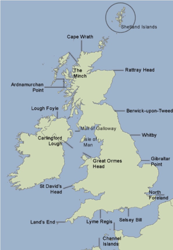
The map shows the places referenced to define the areas of the forecast. The forecast areas extend 12 nautical miles offshore. Bear in mind that this does make the area that the forecast applies to quite large and the forecast will tend to give the worst conditions likely within that area. Most modern forecast apps will give you much greater detail than this.
You hear the following over your VHF:
‘The inshore waters forecast, issued by the Met Office at 05:00 UTC on Tuesday 2 June 2017 for the period 06:00 Tuesday 2 June to 06:00 Wednesday 3 June. St Davids Head to Great Orme Head, including St Georges Channel. 24 hour forecast: West 3 or 4, backing southwest 6 or 7, later. Smooth, becoming moderate later. Rain later in north. Good, occasionally moderate later.’
How does this affect your paddling plans on Anglesey?
The weather for today’s paddle seems reasonable for a competent group, but we might choose to start the day paddling westwards into the wind so we can be blown home. We expect less than 0.5 m waves. Visibility should be at least 5 miles.
The weather ‘later’ - i.e. after 18:00 UTC or 19:00 British Summer Time sounds decidedly worse, but we’ll be off the water by then. The wind overnight would make paddling difficult, as would the waves up to 2.5 m. We’d expect rain, which will limit visibility to 2-5 miles.