5.2 Fixes
Position fixing is the art of working out where you are on the sea. This doesn’t need to be complicated. Lots of methods exist. We’ll cover a few here, from the simple to the more complex:
- ‘Single point fix’ - simply noticing that you’re at an obvious landmark, like a buoy or a feature on the coastline.
- GPS systems can be used to fix position. There’s many different ways to use GPS. It’s often easier to program a (destination) point into the GPS to which it tells you range and bearing than to try and interpret coordinates.
- Three point fix - the classic method of position finding in open water. If a paddler can see two landmarks, they can take a bearing to each one. If they draw lines from each landmark along the bearing, they can fix their position where the lines cross. In practise three landmarks are commonly used to reduce mistakes and give a feeling for the likely error in the fix.
On a paddle from St.Agnes to Samson you wish to fix your position. You take bearings with your compass to the Old lighthouse on St.Agnes (171˚), the Star Castle Hotel (74˚) and the Spencers Ledge buoy (287˚). Where are you?
First, we note that this map has compass variation 3˚ W. We hence subtract 3˚ from each bearing. So, for the Lighthouse, we set our compass to 171-3=168˚. We place it on the map, align it to the north-going gridlines and align an edge with the lighthouse. We then draw a line along the edge of the compass. Repeat for the Hotel and the buoy:
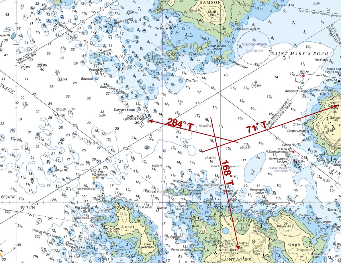
We are likely to be inside, or near, the triangle formed where the bearing lines cross. If we wish to give our position in latitude/longitude it would be:
49˚ 54.6’ N 6˚ 21.0 WAlthough many paddlers rarely use a full three point fix, the principle is useful to know. For example, a paddler might paddle on a bearing towards a target and use occasional bearings to either side of their track to check how far they have come.
You are paddling from the western tip of Samson towards Saint Agnes, heading towards the lighthouse on a transit. You notice the Spencers Ledge buoy to your right, and take a quick bearing to it using your hand compass - 285˚. Where are you and how far do you have to paddle?
Obviously, you’re at the same place as in the example above - with about a nautical mile left to paddle before you reach Saint Agnes.
Whilst the bearing with the hand compass is likely approximate, given you took it quickly, you can be very confident that you’re on a straight line between the western tip of Samson and the lighthouse if you’ve been following a transit. If you also noticed that the Star Castle Hotel was to your left, in a direction roughly at right angles to your track, you could be fairly confident in your position.
Chart © Crown Copyright and/or database rights. NOT FOR NAVIGATION. Reproduced by permission of the Controller of Her Majesty’s Stationery Office and the UK Hydrographic Office (www.GOV.uk/UKHO)