5.1 Transits
Paddling across open water, if we can see where we are going, seems simple. However, as we saw previously, under the effects of tide and/or wind we may not end up where we expect.
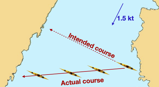
We need to find a way to correct for the influence of tide and wind.
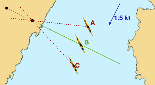
The easiest way to do this is to look for two objects at the planned destination, one behind another, that line up. If these objects stay aligned, the kayaker must be on track (B). If the kayaker is too far the the right (A), the further object will shift to the right. If the kayaker is too far the left (C), the distant object shifts to the left.
This technique is known as paddling on a transit (or, in the US a ‘range’).
Trearddur Bay, Anglesey has somewhat complex tidal flows. It is helpful to use a transit to cross it.
The transit on this occasion aligned the left edge of a house with the steepest part of Holyhead Mountain, as shown in A.
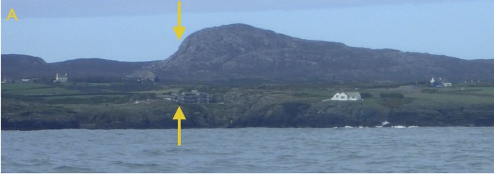
After a few minutes, the background transit (the mountain) was seen to have shifted right in relation to the foreground transit (the house) as in image B.
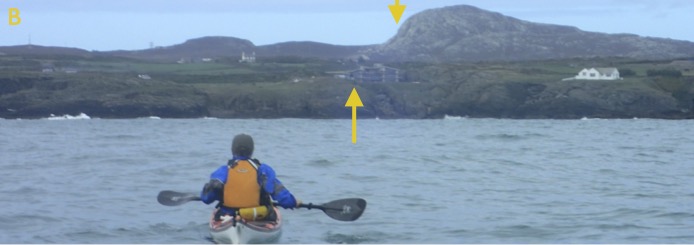
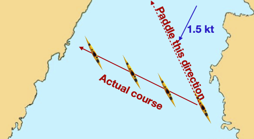
We had clearly been pushed to the right by tide and/or wind, and needed to point further to the left to maintain our course.
Where pilotage for yachts is especially tricky, you may find posts or other prominent markers, one behind the other. These create transits that mark safe lines through rocky channels. As long as the yachtsman keeps the white posts in line, they can expect to remain in deep water.
However, there’s no need to follow pre-placed transits. Any two features that line up where you want to go will do.
Often, the texture of the rock of a sea cliff provides a satisfactory front marker to use as a transit along with some feature on the horizon of the land behind.
Paddling to offshore islands with no visible land behind presents a particular challenge. Often, insufficient detail can be picked out on the island to form a transit.
Some options might be used in this case:
- Use a reverse transit - i.e. one that is behind you rather than in front of you. Obviously, to make this work, you need to keep looking back over your shoulder
- Take a bearing towards the island and periodically check to see if this bearing remains constant. This tends to give less immediate feedback than the transit method
- Use the paddle shaft as a straight edge. Place one eye against the paddle shaft, so that you are looking along it. Point the paddle shaft towards the island - you should see the paddle shaft extending in a straight line from your eye towards the island. Without moving the paddle shaft, turn your head such that the other eye is looking along the paddle shaft in the opposite direction. If you’re on course, the shaft should point towards the point where you departed from the shore.