4.9 Coastal pilotage
Pilotage is the art of finding your way around within sight of land, using visual references. It is considered distinct from ‘Navigation’ (with a capital N!), which often refers to finding ones way away from land, or without good visual references. The ‘formal navigation for short crossings’ section discussed a simple example – the bearing that we calculated could, in theory, be followed even in thick fog with no visual references.
Most sea kayak navigation is really pilotage – making the most of the things that we can see.
The simplest approach to coastal navigation is simply to follow a linear feature (like a coastline) and know how far along this we are by the things that we have passed.
What landmarks would we expect to see on a paddle from Portloo to Old Town?
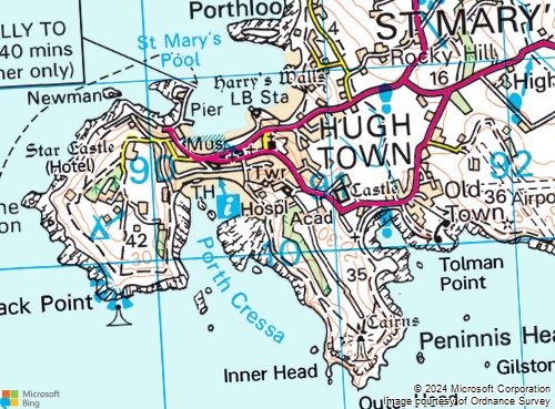
Paddling out of Portloo, turn left around a rocky area (island at HW). Pass a small beach, a rocky promontory, a second beach and a lifeboat station. Paddle past the town beach and round the pier. Pass a small island, turning left. Pass a point and turn left again. Left again at a point with a beacon offshore. Sharp left inside some islands into a beach with buildings behind. Back out of this bay, past an indent (island) to a major headland (lighthouse). Round the headland, offshore island, smaller headland and into Old town bay (look for main road and the town).
4.9.1 Distance, speed and time
It is useful and good practice to estimate the time that should be taken to get to the next waypoint on the route. This enables estimation of how far has been paddled (e.g. ‘we’re half way there’) and acts as a check on the speed of the group. Slow progress could indicate tired paddlers or an unexpected tidal stream in the opposite direction.
If speed is known, time taken in minutes can be estimated by multiplying the distance in nautical miles by:
- 30 for 2 knots speed
- 20 for 3 knots speed
- 15 for 4 knots speed
How long will it take to paddle from Portloo to Old Town at 2 knots?
The distance is a little tricky to measure around the wiggly coastline. It is around 6 grid squares = 6 km. 6 km is approximately 3 nautical miles.
Time taken = distance / speed = 3 / 2 = 1.5 hours = 90 minutes
Or, using the numbers given above, time taken = 3 miles X 30 = 90 minutes
4.9.2 Dead reckoning
If we know how fast we’re paddling, and how long we’ve been paddling since we passed a particular point, we can calculate how far from that point we are. If we also know what direction we’re paddling in (e.g. by following the coast, or by paddling on a bearing), then we can estimate where we are. This process is known as ‘dead reckoning’. It should be done with caution, as it ignores the effect of wind and taking tide into account can be tricky.
4.9.3 Compass use for coastal pilotage
Many kayakers see their steering compass mainly as a tool to be used for open crossings. In fact, they can be very useful when following coastlines. A kayak following the coast normally points in the direction of the coastline, so glancing at the compass tells you which direction the coastline is running in. Keeping an eye on this is a good habit to get into:
You can easily spot places where the coastline changes direction - at a corner or headland.
If the coastline follows a gradual curve, you can estimate how far around the curve you are.