4.5 The compass
Compasses are useful as they allow us to set direction on the water relative to (magnetic) north. Two types are commonly used on a sea kayak:
- A hiking (baseplate) compass is used for measuring bearings on charts and taking bearings of objects from the cockpit.
- A steering compass is mounted to the front of a sea kayak. It is used to determine the direction that the boat is pointing.

The simplest way to use a compass is to align a map by aligning the north-going lines on the map with the compass needle (ensuring the red end of the needle points towards the top of the map). Setting a map in this way often helps with orientation.
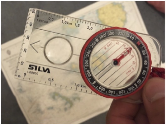
One use of a compass is simply as a protractor to measure bearings on a chart. To do this:
- Align the side of the compass along the bearing that you wish to measure. Check that the arrow on the compass base plate points along the bearing direction.
- Rotate the bezel of the compass to align the lines inside the bezel with north-pointing grid lines on the map
- Read off the bearing at the fiducial mark (black line) at the edge of the bezel scale.
What is the bearing of Gull point from Wras island?
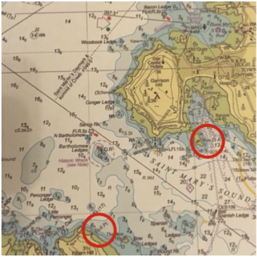
Place one edge of the compass along the bearing to be measured – here the lower edge of the compass is aligned between Wras island and Gull Pt.
Check that the arrow on the base plate points in the right direction – here we are measuring a bearing from Wras to Gull Pt., so the arrow is pointing in the correct direction – towards Gull Pt:
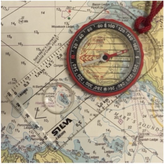
Twist the Bezel until the red lines inside it align with the north-going grid lines on the map.
Read off the bearing from the mark on the edge of the bezel. Here it is 230˚
Chart © Crown Copyright and/or database rights. Reproduced by permission of the Controller of Her Majesty’s Stationery Office and the UK Hydrographic Office (www.GOV.uk/UKHO)
Grid lines on maps and charts do not point exactly towards the magnetic north that a compass needle aligns with. However, the difference is currently very small in the UK - so if you’re based in the UK and new to compass use, you might want to ignore the info below on magnetic variation.
Magnetic variation Unfortunately, the grid lines on maps and charts do not point towards the magnetic north that a compass needle aligns with. This is because the location of the magnetic north pole is not in the same position as the north pole used as a datum for grid systems. The difference between the map’s grid north and the magnetic north that the compass points to is called magnetic variation. It varies from place to place and from year to year. Magnetic variation is shown on maps and charts.
Magnetic variation in the UK is very small – generally 3˚ or less. This is a greater than the level of accuracy that can really be achieved on a kayak deck. As such, corrections for variations can be ignored for many practical purposes.
To convert from bearings taken from the map to magnetic bearings, westerly variation (typical in UK) is added to the bearing. A subtraction is required to go from magnetic bearings to true (map) bearings. However, it’s worth noting that some areas of the UK now have easterly variation on OS maps.
What is the bearing of Gull point from Wras island with reference to magnetic north?
We measured the bearing as 230˚T (T=with reference to true north).
On the chart we find a compass rose that indicates magnetic north. It reads: 3˚00’W 2015 (9’E):
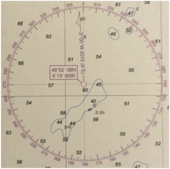
This means that magnetic north was 3˚W of grid north in 2015, and is moving east (i.e. variation is decreasing) by 9’ a year.
It is now 2017, so variation will be 2˚42’W. Let’s take it as 3˚ at a reasonable level of accuracy.
Being westerly variation, this must be added to the bearing to give 233˚MN (magnetic).
Once a compass has been set to a bearing as described above it can be picked up off the map and rotated until the red north needle aligns with the red arrow within the bezel.
The arrow on the compass base plate now points along the bearing that we have set the compass bezel to.
The process above can be reversed to transfer a bearing measured across the water to a chart. For example, if you want to know which lighthouse you’re looking at:
- Point the compass base plate arrow at the lighthouse
- Twist the bezel until the red part of the needle aligns with the red arrow
- Place the compass on the map, with the red lines within the bezel aligned with the north-going grid lines
- Place the edge of the compass on your current position
- The lighthouse should appear on the chart somewhere along the same edge of the compass.