1.1 Forecasts
The main things to know about the weather are where to find a good forecast and how to interpret it.
Unsurprisingly, the internet is a great source of weather information. Good sites include:
- https://www.metoffice.gov.uk - the ‘official’ forecasts for the UK, including marine forecasts
- http://magicseaweed.com - designed for surfers, but gives usable wind and wave information
- https://www.windy.com - my current favorite site
- https://www.windfinder.com - usable interface and a good phone app
- http://marine.meteoconsult.co.uk/marine-weather-forecast/weather-forecast-coastline.php
- https://www.windguru.cz
Most of these forecasts will give the following information:
- Wind speed - see below.
- Wind direction - typically given as the direction that the wind will blow from. However, many forecasts will provide an arrow in the direction that the wind is blowing to. Useful to know, as we can plan paddles that start by going upwind to give us an easy homeward leg, or we can choose to find shelter behind the land (but beware the dangers of an offshore wind).
- Wave height - can our group cope with the forecast waves? What effect will they have when they strike the coast? Waves of 1 meter will feel serious to an inexperienced group. This is about the height when group members will sometimes disappear in the troughs.
- Wave period - long period swell is easier to paddle in than short period chop. However, long period swell implies a bigger wave for a given height, so the effect of the wave breaking will be more powerful.
- Wave direction - suggests where we can find shelter.
- General weather - cloud, precipitation, temperature - how miserable or pleasant will the day be? How much of a danger is hypothermia if things go wrong?
It is important to be able to understand the effect that the wind will have on us as sea kayakers. The table below describes conditions at each level of the Beaufort Scale, along with wind speeds in other units. The ‘speed against wind’ column gives a rough idea of how fast an experienced group might be able to paddle upwind - for less experienced groups, the drop in speed with increasing headwind will be more dramatic. The ‘limit of adequate reserve’ give some idea of how long a competent paddler might be happy paddling in the specified conditions.
| Beaufort force | Speed in knots | Sea conditions | Land conditions | Paddling | Speed against wind (knots) | Limit of adequate reserve (hours) |
|---|---|---|---|---|---|---|
| 1 | 1-3 | Small ripples | Smoke drifts, but wind vanes don’t move | Easy | 3 | 8 |
| 2 | 4-6 | Small wavelets that don’t break | Wind felt on face, leaves rustle and wind vanes move | Easy, small choppy waves start to form. | 3 | 8 |
| 3 | 7-10 | Large wavelets, which occasionally break | Leaves and twigs in motion, light flags extend | Fairly easy. Noticeable work paddling into headwind. Novices struggle in crosswind. | 2.75 | 7 |
| 4 | 11-16 | Small waves, frequent white horses | Raises dust, small branches move | Effort into headwind. Following seas start to form. Novices struggle to control the boat. Can be difficult to keep groups together unless all are competent. | 2.75 | 4 |
| 5 | 17-21 | Moderate longer waves. Many white horses, some spray | Small trees sway | Hard effort and paddle flutter. Cross winds awkward. Constant effort and concentration required to control the kayak. | 2.5 | 2 |
| 6 | 22-27 | Large waves, extensive foam crests and spray | Large branches in motion, hard to use umbrellas | Very hard effort. Limit of paddling any distance into wind. Following seas demand concentration. Only suitable for short trips by experienced paddlers. | 2.25 | 1 |
| 7 | 28-33 | Sea heaps up, foam starts to streak | Whole trees in motion, inconvenient to walk against wind | Strenuous and likely dangerous. Following seas need expertise. Paddling across wind very hard. | 1.5 | 0.5 |
It is useful to be able to interpret the inshore waters forecast issued by the met office. This is available:
- on the Met office website
- on Radio 4
- over VHF radio at regular intervals
The forecast includes the following elements, in order:
- Wind strength (Beaufort scale) and direction -e.g. “West 4 or 5, backing southwest 5 or 6 later.”
- Sea state - e.g. “Slight or moderate.” See below.
- Weather - e.g. “Occasional rain later.”
- Visibility - e.g. “Good.”
Some of the terms used in the forecast are explained in more detail below.
Timing - the words used have precise meanings:
- Imminent: within 6 hours
- Soon: 6-12 hours
- Later: >12 hours
Sea state - innocuous sounding sea states can cause problems for kayakers:
- Calm: <0.1 m wave height
- Smooth: 0.1-0.5 m
- Slight: 0.5-1.25 m
- Moderate: 1.25-2.5m
- Rough: 2.5-4m
Visibility
- Good: > 5 miles
- Moderate: 2-5 miles
- Poor: 1 km to 2 miles
- Fog: < 1 km
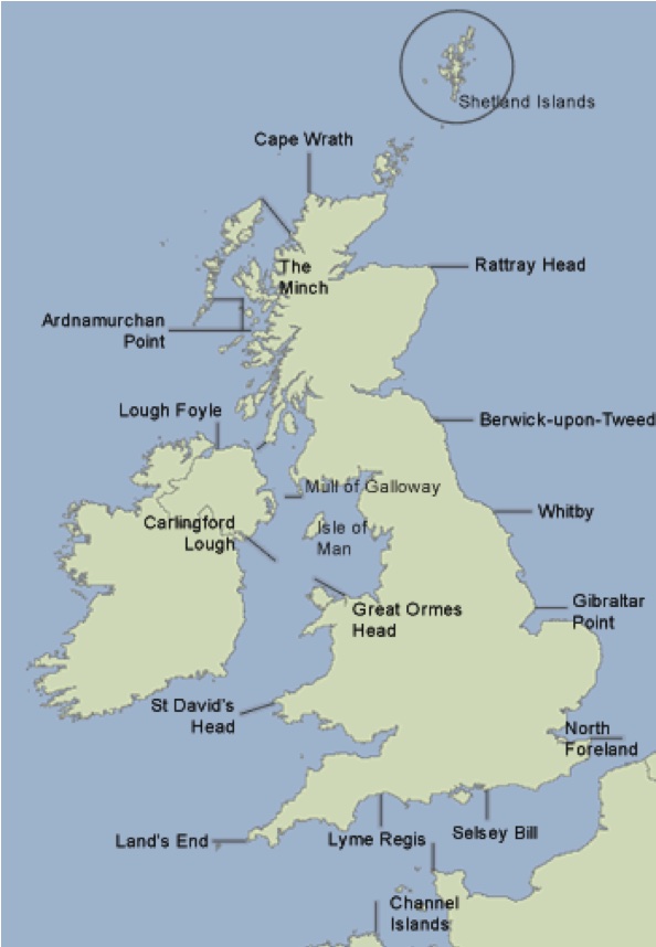
The map shows the places referenced to define the areas of the forecast.
You hear the following over your VHF:
‘The inshore waters forecast, issued by the Met Office at 05:00 UTC on Tuesday 2 June 2017 for the period 06:00 Tuesday 2 June to 06:00 Wednesday 3 June. St Davids Head to Great Orme Head, including St Georges Channel. 24 hour forecast: West 3 or 4, backing southwest 6 or 7, later. Smooth, becoming moderate later. Rain later in north. Good, occasionally moderate later.’
How does this affect your paddling plans on Anglesey?
The weather for today’s paddle seems reasonable for a competent group, but we might choose to start the day paddling westwards into the wind so we can be blown home. We expect less than 0.5 m waves. Visibility should be at least 5 miles.
The weather ‘later’ - i.e. after 18:00 UTC or 19:00 British Summer Time sounds decidedly worse, but we’ll be off the water by then. The wind overnight would make paddling difficult, as would the waves up to 2.5 m. We’d expect rain, which will limit visibility to 2-5 miles.
It is useful to look at weather forecasts for the periods before and after our planned paddle:
Windy conditions before the time we’re on the water can generate waves that persist. And it’s possible that the timing of any weather changes isn’t forecast precisely.
It’s useful to be aware of any forecast changes later in the day - these might occur earlier than forecast, and, of course, it’s possible that the paddle takes longer than we expect.