Chapter 9 Google Maps Platform
9.1 Google Tackeout
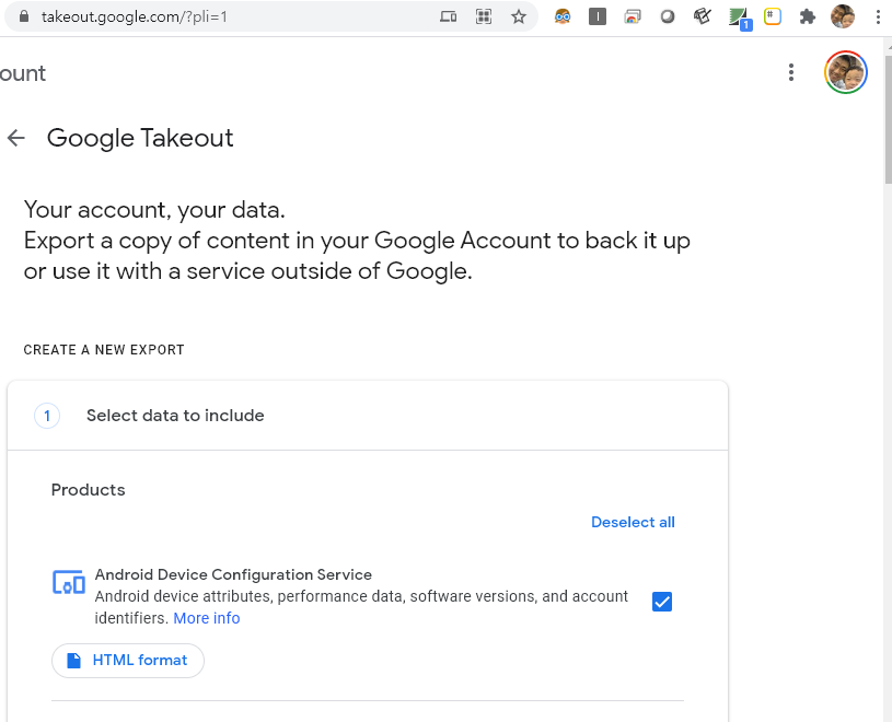
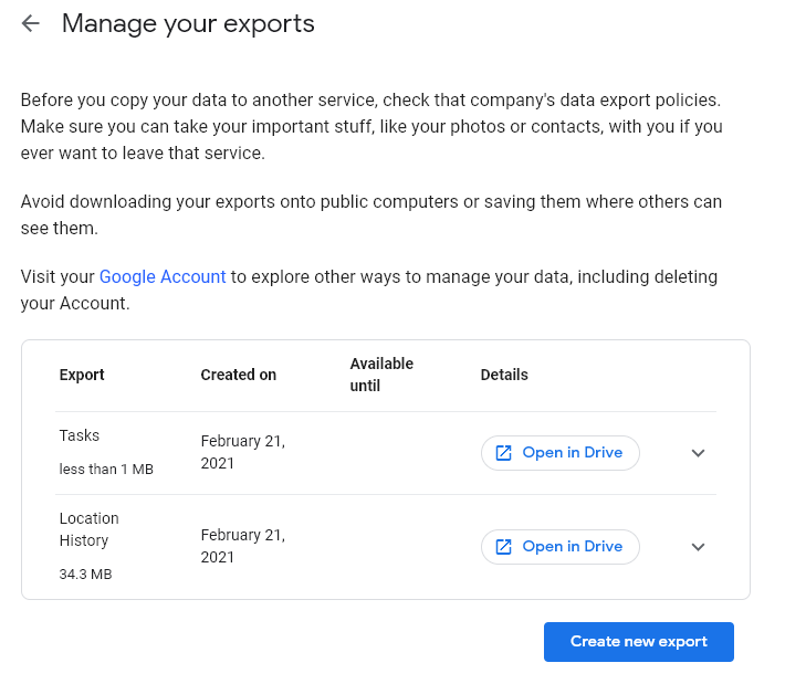
구글에서 기록되어 있는 지도 데이터를 다운로드 받아 봅시다.
Google Takeout
- following steps
- https://takeout.google.com
- deselect All
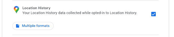
- select
Location History - export
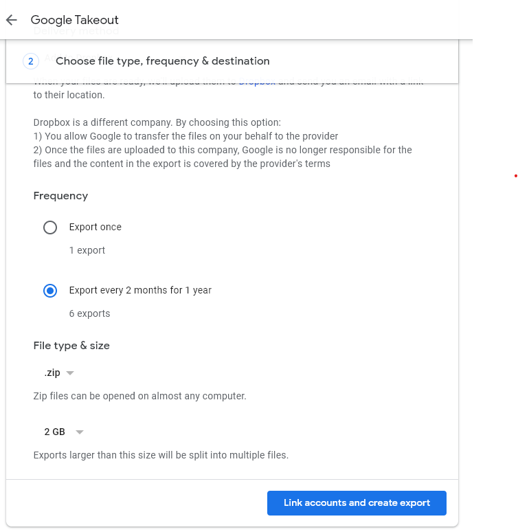
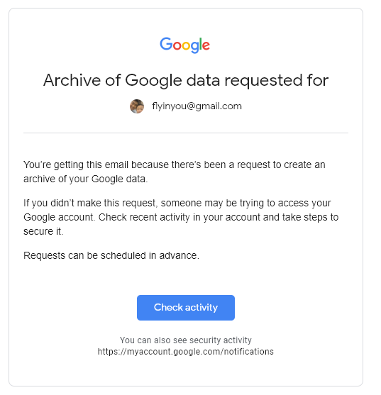
- go to gmail and check activity, and back to takeout.google.com
- click
downloadwith optiongoogle-drive - check Takeout folder in google-drive
takeout googlecom
google location history
google location history
google location history export
google takeout 4
google takeout 5
google takeout 5
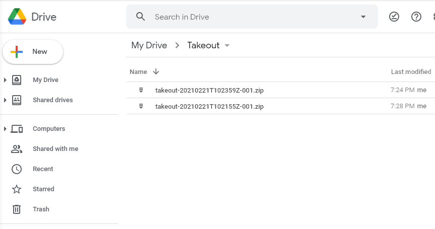
google drive download
- download takeout file from google drive
- takeout export option: google drive download
- check update data (every two month)
- goto google drive
- library(googledrive)
- download data
자 이제 package 를 설치하고 library 를 불러와 보겠습니다.
이후 drve_auth()를 실행하여, google drive에 접속하겠습니다. 이후 나오는 과정은 allow 를 계속 눌러주시고, 마지막에 나오는 key는 복사하여 consol창에 붙여 넣기 합니다. 동영상은 leaflet, 위치와 시간표시쳅터에 있습니다.
## install packages
if(!require('googledrive')) install.packages('googledrive')
## load library
library(googledrive)
options(httr_oob_default = TRUE)
drive_auth()
ls <- drive_ls(path = '/Takeout/',
               pattern = "*.*")
ls
구글 드라이브에서 몇가지 파일을 찾아 보겠습니다. google drive에서 계정 확인 및 권한을 물어볼 텐데 yes 하시면 됩니다.
## link to google drive author...
  drive_find(n_max = 10)
## serach
drive_find(type ="file", pattern ="Takeout/takeout-*.zip", n_max = 100)
ls <- drive_ls(path = '/Takeout/',
               pattern = "*.*")
ls$name
ls$id
여기에 name은 파일 이름이고 id가 있을 것입니다. id는 구글 파일을 다운로드 할 때 쓸 주소 같은 것으로 생각하시면됩니다. 압출 파일로 되어 있으니 다운로드 받아 보도록 하겠습니다. 저는 여러 이름 중에 2번째 파일을 다운로드 받겠습니다. 여러 분들오 몇번째 파일을 다운로드 받을 지 생각해보시고 해보세요.
temp  <- tempfile(fileext = ".zip")
data1 <- drive_download(as_id(ls$id[2]),
                        path = temp,
                        overwrite = TRUE)

out <- unzip(temp, exdir = paste0(getwd(), "/data"))
out
자 이제 준비가 거의 다 되었습니다.
9.2 Data visualization
json 파일로 되어 있으므로 이를 받아서 읽고 visualizaton을 해보도록 하겠습니다. 필요한 package를 다운로드 받아 보겠습니다.
if(!require(jsonlite)) install.packages('jsonlite')
if(!require(ggmap))    install.packages('ggmap')
if(!require(ggplot2))  install.packages('ggplot2')
library(jsonlite)
library(ggmap)
library(ggplot2)
library(tidyverse)
다운로드 경로가 아래와 같이 되었네요. 여기서 location을 가져와서 위도와 경도를 설정하고 그 위치에 맞게 점을 표시하려고 합니다.
map_data = fromJSON("data/Takeout/Location History/Location History.json")위도와 경도를 생성해 주는 data step을 진행하고, 50000건의 정보만 남기겠습니다.
#map_data$locations

locations = map_data$locations
loc_dat1 =  locations %>%
  mutate(lat = latitudeE7/1e7,
         lng = longitudeE7/1e7) %>%
  mutate(year = str_sub(timestampMs, 1, 2),
         month= str_sub(timestampMs, 3, 4))

loc_dat_sample = loc_dat1 %>%
  slice(1:50000)
구글 지도를 불러오겠습니다. 구글 지도를 사용할 때는 API key가 필요합니다. API key를 얻는 것은 다음 챕터에 설명이 되어 있으니 참고하세요.
key<-read.csv('security/gapi.csv')
register_google(key = key[1,2])
map = get_map(c(127.024612, 37.532600),
              zoom = 10,
              source = 'stamen',
              maptype = "toner")
## Source : https://maps.googleapis.com/maps/api/staticmap?center=37.5326,127.024612&zoom=10&size=640x640&scale=2&maptype=terrain&key=xxx## Source : http://tile.stamen.com/toner/10/872/395.png## Source : http://tile.stamen.com/toner/10/873/395.png## Source : http://tile.stamen.com/toner/10/874/395.png## Source : http://tile.stamen.com/toner/10/872/396.png## Source : http://tile.stamen.com/toner/10/873/396.png## Source : http://tile.stamen.com/toner/10/874/396.png## Source : http://tile.stamen.com/toner/10/872/397.png## Source : http://tile.stamen.com/toner/10/873/397.png## Source : http://tile.stamen.com/toner/10/874/397.png이제 지도를 다운 받았으니, 여기에 제 위치를 살펴 보도록 하겠습니다. 월 별로 색을 다르게 하여 표시해 보겠습니다. 7월에는 원주 건강보험공단 빅데이터 분석한다고 다녔던게 남아 있네요. 나머지 달에는 여러 공장에 돌아다닌 것이 나타나네요.
ggmap(map) +
  geom_point(data = loc_dat_sample,
             aes(x = lng, y = lat, color = month), alpha = 0.5) +
  theme(legend.position = 'right') +
  labs(
    x = 'longitute',
    y = 'latitude',
    title = "Location history of me"
  )
## Warning: Removed 6644 rows containing missing values (geom_point).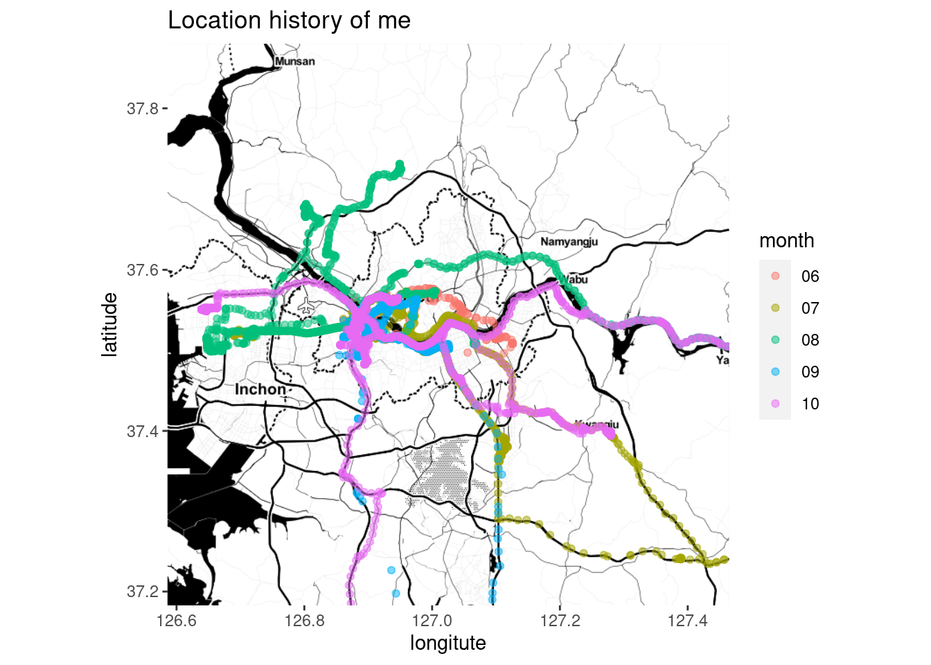
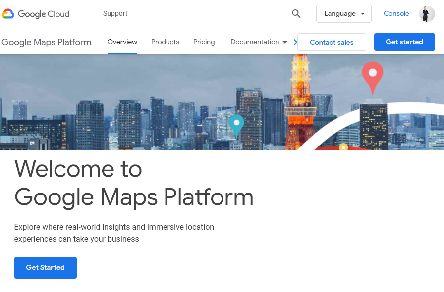
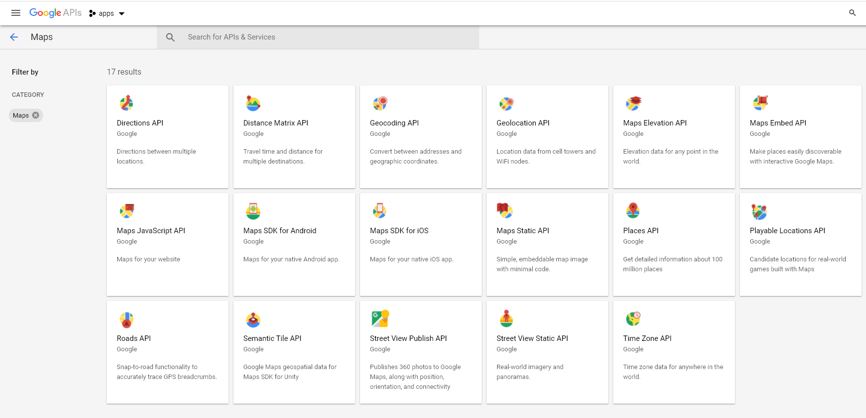
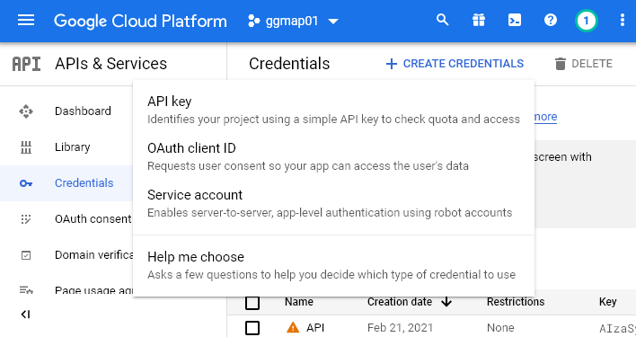
9.3 google API
구글 map을 사용하기 위해서는 Geocoding API 를 이용해야 합니다.
구글 map API
- https://cloud.google.com/maps-platform/
- click
get start API libraryand View all of MapsMaps Static API→EnableCredentials→API key- copy and paste Key
google map api 1
google map api 2
google map api 2