Chapter 1 Basic Concept
Before using of the EDHM it’s very important to know the basic concept and primary idea about EDHM.
1.1 Important Elements of EDHM

In EDHM the two mostly characters are modularization and vectorization-arithmetic, modularization focus on the coupling of the different modules of the hydrological processes, benefit by the modularization it’s very convenience to change the method of process, what means the editable model; vectorization-arithmetic is very useful for the distributed hydrological model, it can greatly short the calculate time, especially when there are many grids (calculate units).
The water cycle of the Earth system and its variability at global, regional and local scales are influenced by a range of processes and mutual interactions, feedback mechanisms and as well as affected by anthropogenic processes.(Rast, Johannessen, and Mauser 2014)
In EDHM a PROCESS is the mapping from those hydrological processes in a digital from, at the same time it’s also the group (set) name of the some MODULEs those haven the same problem to solve and same aims, and a MODULE is the definite method of a PROCESS, it can also undersatnd as:
MODULE = PROCESS \(\times\) Method

For example SNOW is PROCESS mapping the process that snow melting, accumulate and the state variety, SNOW.17 is then the true function that you can call in R, with the method by Andrson(Anderson 1973) forward.
The PROCESS based on the hydrological processes, but sometimes a little different, due to the manual calculate factors in the lang time, some like evapotranspiration is a typical hydrological process, but in EDHM es is diveded into ReferenceET (reference evapotranspiration) and ActualET (actual evapotranspiration) two parts, because the most conceptual models calculate evapotranspiration in the two steps.
In the following section will show the meaning of hydrological processes and the mapped PROCESS.
MODEL is a coupled complete process with some subprocesses (also possible only one process), in EDHM is a true function to simulation the designed model with definite methods. It’s also a set of MODULEs, those realize different process and correctly by the physical process, it can also undersatnd as:
MODEL = \(\sum\) MODULE\(_i\)
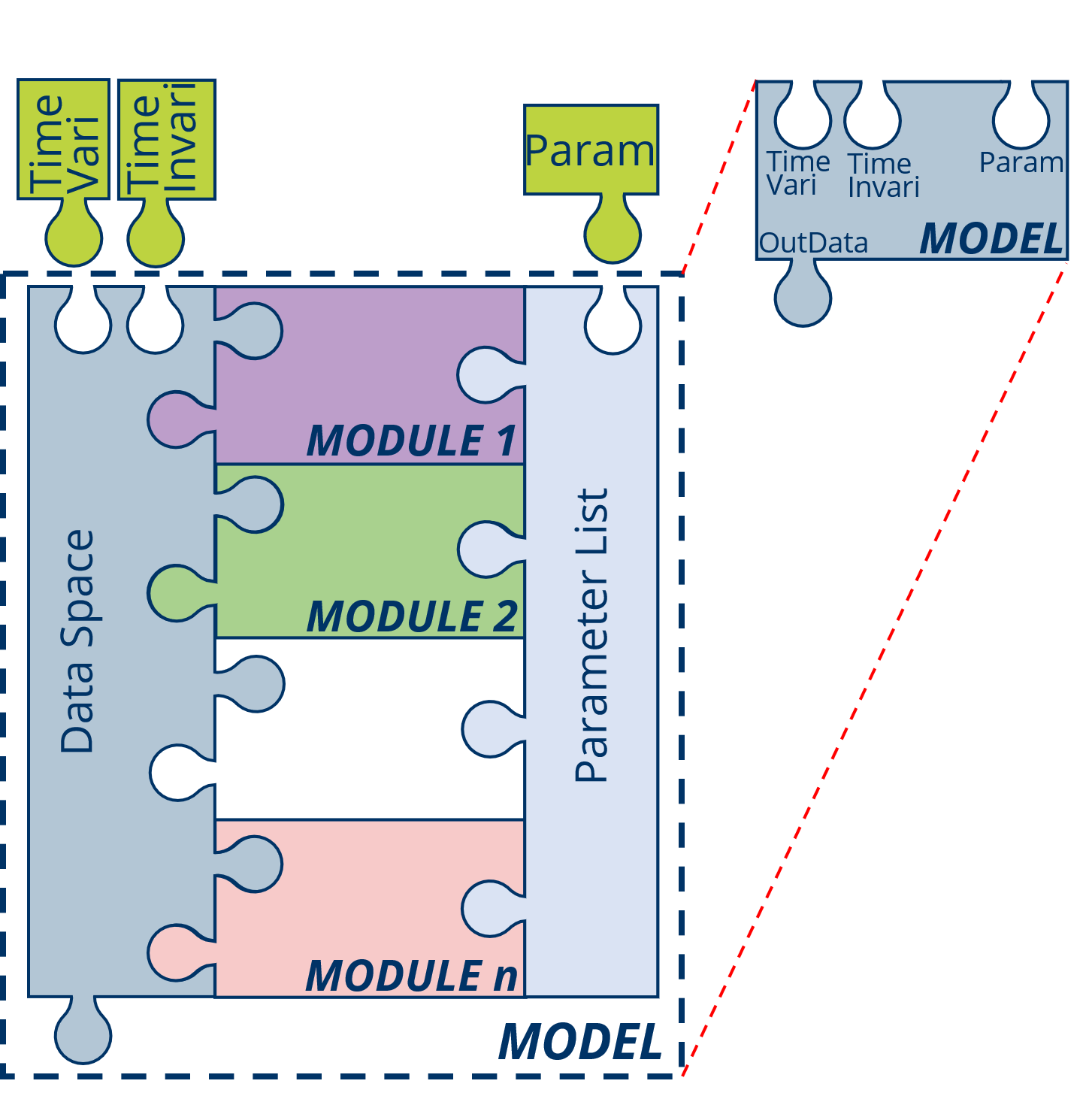
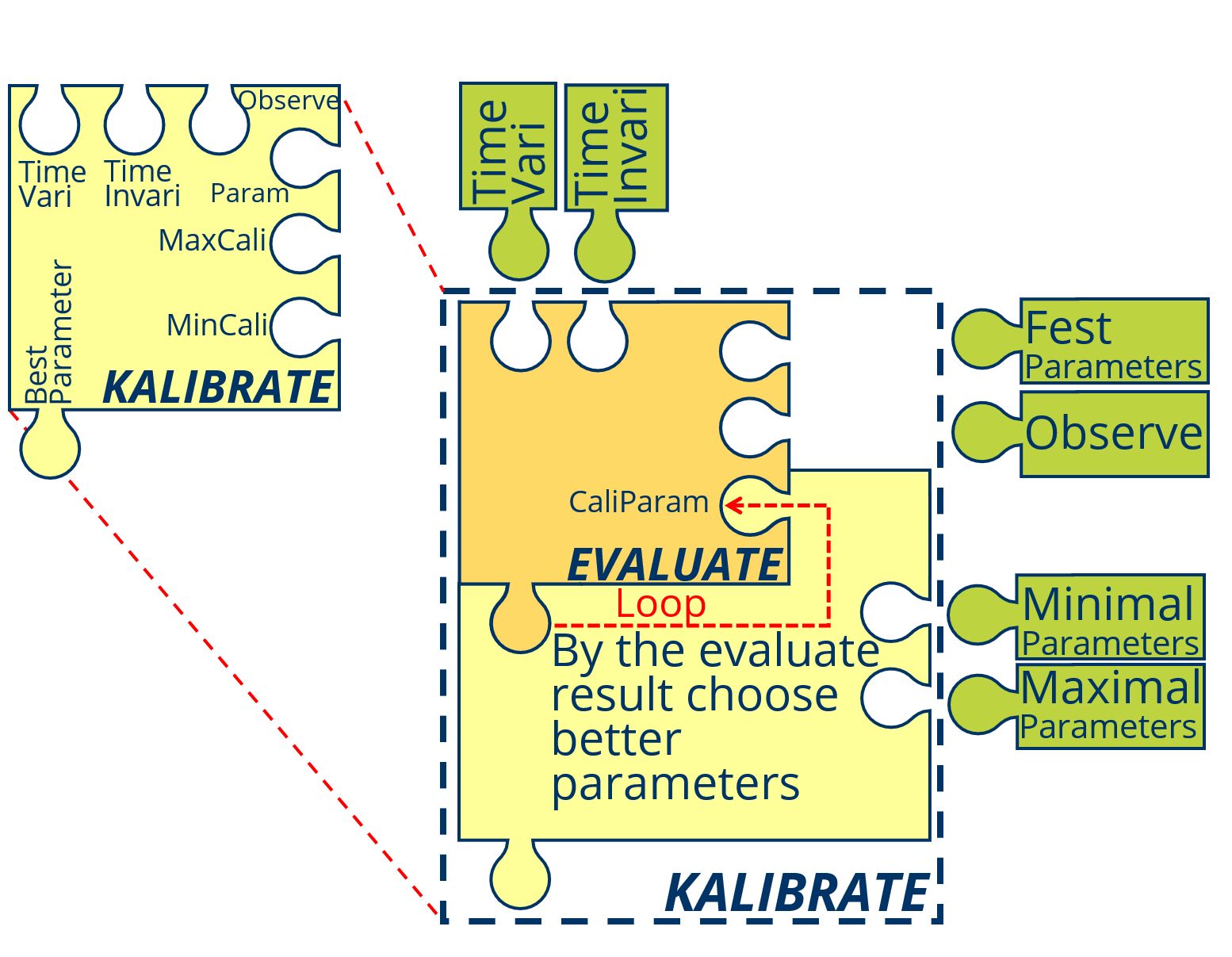
In addition to the PROCESS, MODULE, MODEL there are also some other concept oabout EDHM, some like: function, Run_MODEL, EVALUTE and KALIBRATE.
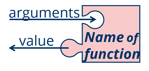
Essentially a MODULE or a MODEL is a function in R, so in R a function make up of name, arguments and body, except the output return / value is also very important.
The name of a MODULE composed of a PROCESS and Method, lik ReferenceET.Hargreaves; the name of a MODEL composed of “MODEL” and a model method, like MODEL.CVIC.
The arguments of MODULE and MODEL are fest in the form “InData, Param, …” for MODULE and “TimeVariData, TimeInvariData, Param, …” for MODEL, so for the data transfer it’s very important to set the same structure as “Data_” dataset.
The body is the most important part of a function (MODULE or MODEL), generally it depended on the method.
The OutData (value) is also so important that not ignore, it must use the GROUP-VARIBLE type as InData.
Excepted, the reference and a data set, that make up of InData, Param and OutData can’t be omitted, especially when the MODULE or MODEL are also for the other aviable.
The arguments of a MODULE of include: InData and Param
The VARIABLE is the data those describe the state or character of the environment and the volume or character of water in different process. And in order to quickly find the VARIABLE and avoid the duplicate name of VARIABLE, the GROUP is like the folder of VARIABLE designed, for example in GROUP Evatrans (evapotranspiration) include the VARIABLEs RET (reference evapotranspiration), AET (actual evapotranspiration) and so on.
In EDHM the VARIABLE saved as common type of for time-invariable VARIABLE, it depend on the MODEL or MODULE or “t_vari.array” that base on “array” type for time-variable VARIABLE. The first dimension must be the time-dimension. When it also has heterogeneity in horizontal spatial space, the second dimension slways is the space-dimension. In EDHM the spatial data are divided in to many GRID, in the using of MODEL the spatial contact between the GRIDs will ignored, all of GRIDs must have a ID (index) form 1 to number of GRIDs. But it’s not important, how to divide the research region. For some VARIABLE there are also different layers, it can put in third demenision.
VARIABLE are putted in the GROUP
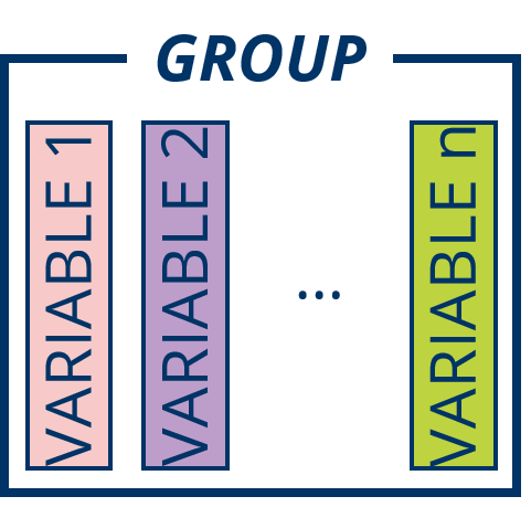
InData is a list of all VARIABLE the MODULE needed, like previous section explained the VARIABLEs must putted in the GROUP.
Pram is the parameter list of all the empirical parameters (different as function arguments) of the MODULE.
You can check the MODULE needed VARIABLE (InData) and parameters (Param) with “Data_” + MODULE name in R, some like Data_ReferenceET.Linacre and the same time every Param give the suggested maximal and minimal value of the parameter in this MODULE.
You can also check the same content in the R Help windows with the MODULE name.
The output of the MODELUE have the similar structure like InData, the VARIABLE of OutData is also include in the “Data_” dataset.
The Data_XXX is a list that had added in EDHM package, the using about it will show in the next chapter.
Different from MODULE the input variable of MODEL will divided in to TimeVariData and TimeInvariData:
TimeVariData is the dataset of all VARIBLE those are variable in the time serie, e.g. TAir, Precipitation and other meteorological data.
TimeInvariData is the dataset of all VARIBLE those are invariable in the time serie, e.g. Latitude, Elevation and other geological and topography data.
The aim to the division is in order to convenient get the data of one time step. Actuly the most MODULE can only deal with on time step data, because the state is associated to the last time step, in the MODULE there are no timely loop, only in MODEL there is a loop.
But for some MODULE, those not contact with last time (e.g. all MODULE in PROCESS ReferenceET) or the full time data are known (e.g. ROUTE.G2RES), you can calculate the whole time series without loop.
Step is special unit in EDHM, in EDHM the time serise is divided into many equal time interval, one time interval is a Step, the other units are given by UCUM. The most VAERIABLE like a rate, tempo those unit should be in [mm/Step], will simplify as [mm].
The using of a MODEL is the basic, but the Param (parameters) import base on the name-index not number-index, so it’s essencially to make a Run_MODELL to transfer the parameters, especially when use auto calibration program. In a Run_MODELL function you can set the parameters those need to calibrate or not.
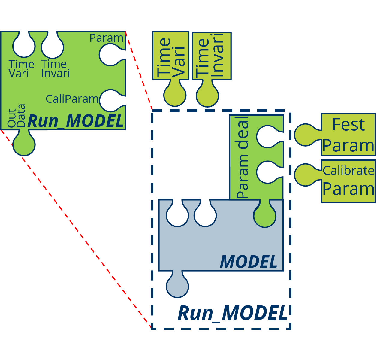
EVALUTE is a process by the application of hydrological model, use the mathematical form to evaluate the results of simulation, scilicet the . The sime time it is slso the basic for CALIBRATE, the most effective method for CALIBRATE is calculated into a number (efficiency), like NSE (Nash-Sutcliffe efficiency), KGE (Kling-Gupta Efficiency).
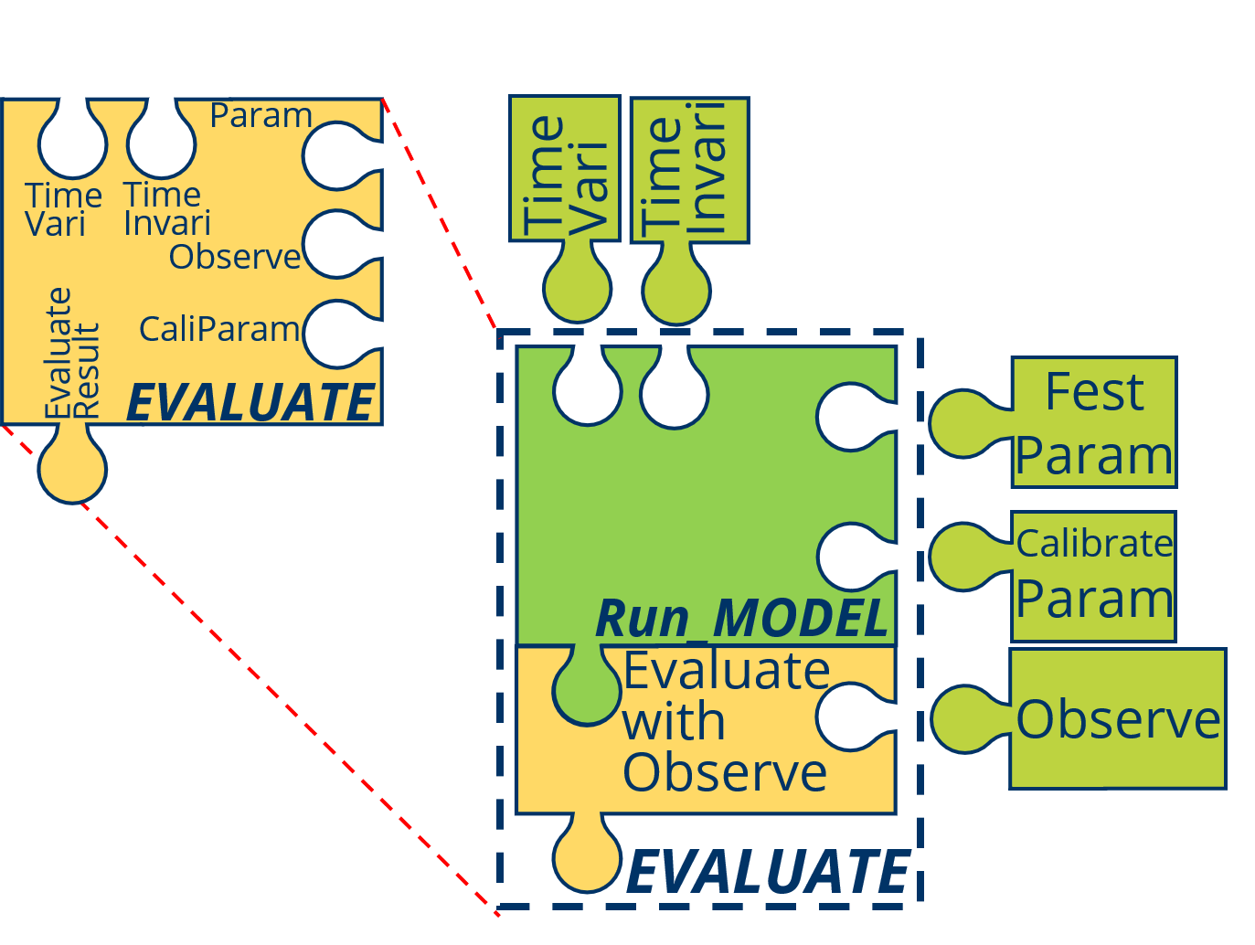
CALIBRATE is also a process by the application of hydrological model, in this process the parameters of the model are varied to minimize the difference between simulation result and observed data.
1.2 Basic Concept of Hydrological Cycle

The hydrological cycle is composed of different components, which include evaporation from water surfaces and bare soil, evapotranspiration from vegetated land, transport of water vapour in the atmosphere, cloud droplet formation and cloud dynamics, the mechanisms leading to liquid and solid precipitation, the movement of water and change in soil moisture in the unsaturated soil, including root dynamics, surface and river run-off, and groundwater flow.(Rast, Johannessen, and Mauser 2014)
Also from (LANGBEIN and ISERI 1960): A convenient term to denote the circulation of water from the sea, through the atmos- phere, to the land; and thence, with many delays, back to the sea by overland and subterranean routes, and in part by way of the atmosphere; also the many short circuits of the water that is re- turned to the atmosphere without reaching the see.
The whole cycle will spilt by the vertical layer in six layers which are Atmosphe, Snow, Canopy, Surface, Subsurface and Ground. There indeed are not the complete hydrological cycle components, limited by the first stage, in the first stage will focus on the conceptual models.
1.2.1 Atmosphere (Atmos)
In the Atmosphere major occur the process precipitation and part of the evapotranspiration, the concept of the evapotranspiration will show in section 1.2.3 in Canopy group.
Precipitation: As used in hydrology, precipitation is the discharge of water, in liquid or solid state, out of the atmosphere, generally upon a land or water surface. It is the common process by which atmospheric water becomes surface or subsurface water * * *. The term “precipitation” is also commonly used to designate the quantity of water that is precipitated. (Meinzer, 1923, p. 15.) Precipitation includes rainfall, snow, hail, and sleet, and is therefore a more general terr than rainfall.
Effective precipitation: 1. That part of the precipitation that produces runoff. 2. A weighted average of current and antecedent precipitation that is “effective” in correlating with runoff.(LANGBEIN and ISERI 1960)
The two most important forms of precipitation are rainfall and snowfall, the other form will not considered in general situation or simulation.
Rainfall: The quantity of water that falls as rain only. Not synonymous with precipitation.
Snowfall: A form of precipitation composed of ice crystals.
In this layer PROCESS PRECDicid and GROUP Prec show in the following Table:
| Variable | Unit | Description |
|---|---|---|
| Precipitation | mm | Precipitation, summe of rain and snow |
| SnowFall | mm | Snow |
| RainFall | mm | Rain |
And the typical meteorological data set MetData
| Variable | Unit | Description |
|---|---|---|
| TAir | Cel | Average Air temperature in Timestep |
| TMax | Cel | Maximal Air temperature in one day |
| TMin | Cel | Minimul Air temperature in one day |
| Actual_vapor_press | mPa | Actual vapor press |
| RelativeHumidity | % | Relative Humidity, not greater than 100 |
| WindSpeed | m/s | Average Wind Speed |
| WindH | m | The hight to mess the WindSpeed |
| SunHour | h | Sunshine duration in one day |
1.2.2 Snow
waterequivalent of snow: Amount of water that would be obtained if the snow should be completely melted. Water content may be merely the amount of liquid water in the snow at the time of observation. (Wilson, 1942a, p. 153-154.)
In this layer PROCESS SNOW and GROUP Snow show in the following Table:
| Variable | Unit | Description |
|---|---|---|
| Ice_Volume | mm | Soild Ice Volume, not depth |
| Liquid_Volume | mm | Liquid Volume |
| SN17_ATI | – | – |
| SN17_HD | mm | – |
| Volume | mm | Summe Volume of Ice and liquid water, not depth |
1.2.3 Canopy
Condensation: The process by which water changes from the vapor state into the liquid or solid state. It is the reverse of evaporation.(LANGBEIN and ISERI 1960)
Evaporation:The process by which water is changed from the liquid or the solid state into the vapor state. In hydrology, evaporation is vaporization that takes place at a temperature below the boiling point.(LANGBEIN and ISERI 1960)
Transpritation: The quantity of water absorbed and transpired and used directly in the bulling of plant tissue, in a specified time. It does not include soil evaporation. (After Blaney, I951a, p. 4.) The process by which water vapor escapes from the living plant, principally the leaves, and enters the atmosphere. As considered practically, transpiration also includes guttation. (Lee, 1949, p. 260.)
Evapotranspiration: Water withdrawn from a land area by evaporation from water surfaces and moist, soil and plant transpiration.(LANGBEIN and ISERI 1960)
Relative evaporation: The ratio of the rate of evaporation from a land or water surface in contact with the atmosphere, to the evaporativity under existing atmospheric conditions. It is the ratio of actual to potential rate of evaporation, generally stated as a percentage. (Derived from Meinzer, 1923, p. 14.) The opportunity for a given rate of evaporation to continue is determined by the available moisture supply. (Meyer, 1928, p. 244.)
Potential evaporation: Water loss that will occur if at no time there is a deficiency of water in the soil for use of vegetation. (Thornthwaite, 1944, p. 687.)
Interception: The process and the amount of rain or snow stored on leaves and branches and eventually evaporated back to the air. Interception equals the precipitation on the vegetation minus stem flow and throughfall (after Hoover, 1953, p. 1.)
In this layer PROCESS ReferenceET, ActualET, INTERCEPTION and GROUP Evatrans show in the following table:
| Variable | Unit | Description |
|---|---|---|
| RET | mm | Reference evapotranspiration |
| EvaporationCanopy | mm | Evaporation from Canopy |
| AET | mm | Actual evapotranspiration |
| Transpiration | mm | Transpiration (water from Root layer of vegetation) |
| EvaporationLand | mm | Evaporation from Landsurface (sometimes cotain the Evaporation from Watersurface like Lake) |
Intercept show in the following table:
| Variable | Unit | Description |
|---|---|---|
| Interception | mm | Interception in Canopy |
Canopy show in the following table:
| Variable | Unit | Description |
|---|---|---|
| StorageCapacity | mm | Canopy Storage Capacity for Intercept and Evaporation from Canopy |
And Aerodyna show in the following table:
| Variable | Unit | Description |
|---|---|---|
| AerodynaResist | s/m | Aerodyna Resist |
| ArchitecturalResist | s/m | Architectural Resist |
| StomatalResist | s/m | Stomatal Resist |
1.2.4 Surface (Runoff, Route)
Runoff: That part of the precipitation that appears in surface streams. It is the same as streamflow unaffected by artificial diversions, storage, or other works of man in or on the stream channels. Runoff may be classified as follows: Classification as to speed of appearance after rain- fall or snow melting: Direct runoff Base runoff Classification as to source: Surface runoff Storm seepage Groundwater runoff.
Surface runoff: That part of the runoff which travels over the soil surface to the nearest stream channel. It is also defined as that part of the runoff of a drainage basin that has not passed beneath the surface since precipitation. The term is misused when applied in the sense of direct runoff. See also, Runoff, Overland flow, Direct runoff, Groundwater runoff, and Surface water.
Direct runoff: The runoff entering stream channels promptly after rainfall or snowmelt. Superposed on base runoff, it forms the folk of the hydrograph of a flood. See also surface runoff. The terms base runoff and direct runoff are time classifications of runoff. The terms ground-water runoff and surface runoff are classifications according to source.(LANGBEIN and ISERI 1960)
Infiltration capacity: The maximum rate at which the soil, when in a given condition, can absorb falling rain or melting snow.(Horton 1933)
Infiltration: The flow of a fluid into a substance through pores or small openings. It connotes flow into a substance in cont distinction to the word percolation, which connotes flow through a porous sub- stance.(Horton 1941)
Overland flow: The flow of rainwater or snowmelt over the land surface toward stream channels. After it enters a stream, it becomes runoff.(LANGBEIN and ISERI 1960)
Streamflow: The discharge that occurs in a natural channel. Although the term discharge can be applied to the flow of a canal, the word streamflow uniquely describes the discharge in a surface stream course. The term “streamflow” is more general than runoff, as streamflow may be applied to dis- charge whether or not it is affected by diversion or regulation.(LANGBEIN and ISERI 1960)
Unit hydrograph The hydrograph of direct runoff from a storm uni- formly distributed ever the drain- age basin during a specified unit of time; the hydrograph is reduced in vertical scale to correspond to a volume of runoff o* 1 inch from the drainage basin. (After Am. Soc. Civil Engineers 1949, p. 105.)
In this layer PROCESS RUNOFF, ROUTE and GROUP Route show in the following table:
| Variable | Unit | Description |
|---|---|---|
| WaterSource | mm | Water Source for Routing, sometimes the same Data with the Runoff |
| UHAll | – | All the UH data for all of the Grids for Routr with IUH |
| TypeGridID | – | The grids type for Routr with IUH |
| TransAll | – | All of the transform Matrix for all of the Grids for Routr with IUH |
| Store | mm | Store in the Route (for some Module) |
| Gr4j_UH1 | – | UH form 1 only for Module ROUTE.Gr4j, made by the function |
| Gr4j_UH2 | – | UH form 1 only for Module ROUTE.Gr4j |
| StaFlow | m3/s | Station Flow in the seted grid |
And GeoData show in the following table:
| Variable | Unit | Description |
|---|---|---|
| Latitude | deg | Latitude |
| Elevation | m | Elevation |
1.2.5 Subsurface (Subsur)
Field-moisture capacity: The quantity of water which can be permarently retained in the soil in opposition to the downward pull of gnvity.(Horton 1933)
Field-moisture deficiency: The quantity of water, which would be required to restore the soil moisture to field-moisture capacity.(Horton 1933)
Field-moisture: Water diffused in the soil, the upper part of the zone of aeration from which water is discharged by the trans- piration of plants or by soil evap- oration. See Field-moisture ca- pacity and Field-moisture defi- ciency.
In this layer PROCESS InfiltratRat, Infiltration and GROUP Infilt show in the following table:
| Variable | Unit | Description |
|---|---|---|
| Infiltration | mm | Infiltration |
| InfiltrationRat | mm | Infiltration Rate (for some INFITRATION Module) |
| InfiltrationRateMax | mm | Maximal Infiltration Rate (for some INFITRATION Module) |
And SoilData show in the following table:
| Variable | Unit | Description |
|---|---|---|
| Porosity | 100% | Soil Porosity, not greater than 1 |
| SaturatedConductivity | m/s | Soil Saturated Conductivity |
| Conductivity | m/s | Soil actual Conductivity |
| WettingFrontSuction | m/s | Wetting Front Suction |
1.2.6 Ground
Base flow / runoff: Sustained or fair weather runoff. In most streams, base base flow is composed largely of ground water effluent. (Langbein and others, 1947, p. 6.) The term base flow is often used in the same sense as base runoff. However, the distinction is the same as that between stream flow and runoff. When the concept in the terms base flow and base runoff is that of the natural flow in a stream, base runoff is the logical term.
Groundwater: Water in the ground that is in the zone of saturation, from which wells, springs, and ground-water runoff are supplied. (After Meinzer, 1949, p. 38r,)
In this layer PROCESS GROUNDWATER and GROUP Ground show in the following table:
| Variable | Unit | Description |
|---|---|---|
| MoistureVolume | mm | Moisture volume |
| MoistureCapacityMax | mm | Maximal Moisture Capacity |
| ZoneMoistureVolume | mm | Moisture volume, when the Ground is in more than one Layer divided |
| ZoneDepth | mm | Ground Depth, , when the Ground is in more than one Layer divided |
| BaseFlow | mm | Base Flow |
| MoistureCapacity | mm | Moisture Capacity |
| Depth | mm | Ground Depth |
| Overflow | mm | Overflow, when the caculated water volume greater than Capacity |
| Runoff | mm | Runoff, it will be more wert, when the Runoff is in different form divided |
Except the above data GROUP, the TimeData describe the time information:
| Variable | Unit | Description |
|---|---|---|
| NDay | – | Day nummer in one year |
References
Anderson, Eric A. 1973. National Weather Service River Forecast System: Snow Accumulation and Ablation Model. Vol. 17. NOAA Technical Memorandum Nws Hydro. https://repository.library.noaa.gov/view/noaa/13507.
Horton, Robert E. 1933. “The Rôle of Infiltration in the Hydrologic Cycle.” Transactions, American Geophysical Union 14 (1): 446. https://doi.org/10.1029/TR014i001p00446.
Horton, Robert E. 1941. “An Approach Toward a Physical Interpretation of Infiltration-Capacity.” Soil Science Society of America Journal 5 (C): 399–417. https://doi.org/10.2136/sssaj1941.036159950005000C0075x.
LANGBEIN, W. B., and KATHLEEN T. ISERI. 1960. “General Introduction and Hydrologic Definitions.” https://doi.org/10.3133/wsp1541A.
Rast, Michael, Johnny Johannessen, and Wolfram Mauser. 2014. “Review of Understanding of Earth’s Hydrological Cycle: Observations, Theory and Modelling.” Surveys in Geophysics 35 (3): 491–513. https://doi.org/10.1007/s10712-014-9279-x.