# install.packages("leaflet")
library(leaflet)
library(tidyverse)Overview
This Leaflet map represents 3D flights of European free-tailed bat spotted from 2017-08-08 to 2017-08-15. There are 8 individual.local.identifier for bats taxonomy Tadarida teniotis.
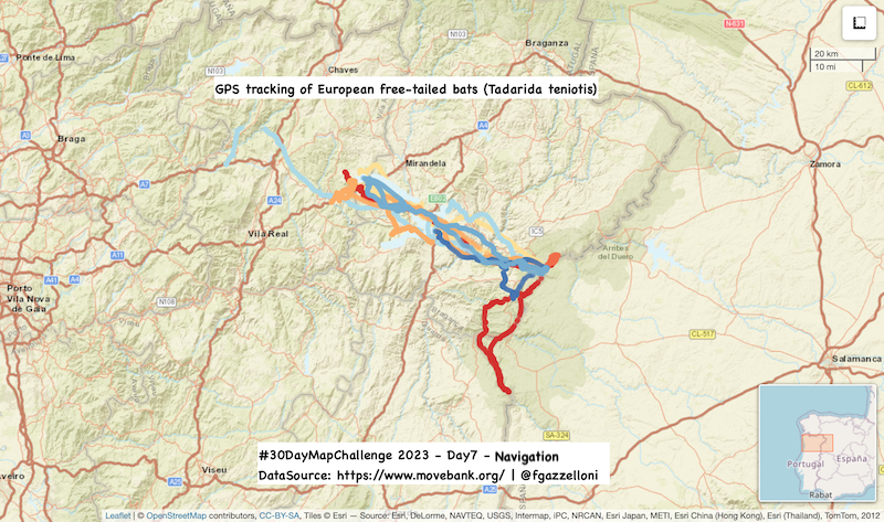
The study results can be accessed on https://www.movebank.org/ and contains data from: European free-tailed bats use topography and nocturnal updrafts to fly high and fast.
O’Mara MT, Amorim F, McCracken GF, Mata V, Safi K, Wikelski M, Beja P, Rebelo H, Dechmann DKN. 2021. Data from: European free-tailed bats use topography and nocturnal updrafts to fly high and fast. Movebank Data Repository. https://doi.org/10.5441/001/1.52nn82r9
Data can be downloaded from the www.movebank.org. In summary, during the day, flying animals use environmental energy sources such as thermal updrafts and wind gradients, but these are considered unavailable at night due to lower thermal potential and difficulty finding uplift sources. Surprisingly, some bat species have been observed flying at high altitudes at night, making energetically costly ascents and reaching remarkable airspeeds. This study confirms that bats utilize orographic uplift to ascend over 1,600 meters and achieve sustained airspeeds of 135 km/h. Wind patterns and topography predict areas suitable for high-altitude ascents, which bats adeptly navigate, capitalizing on vertical wind energy in the nocturnal landscape.
bats <- read.csv("data/3D flights of European free-tailed bats.csv")
bats %>% glimpsebats%>%
count(tag.local.identifier,individual.local.identifier )dat <- bats%>%
select(individual.local.identifier,timestamp,long=location.long,lat=location.lat, ground.speed,height.above.msl)%>%
mutate(date=(as.Date(timestamp)),.after = timestamp)%>%
select(-timestamp)
dat %>% headdat%>%
pull(date)%>%
range()RdYlBu <- colorFactor("RdYlBu", domain = dat$individual.local.identifier)leaflet(dat) %>%
addTiles() %>%
addTiles(group = "OSM (default)") %>%
addProviderTiles(providers$Esri.WorldStreetMap)%>%
addCircles(lng = ~long,lat = ~lat,
color=~RdYlBu(individual.local.identifier),
popup = ~individual.local.identifier)%>%
addMiniMap()%>%
mapOptions()%>%
addMeasure()%>%
addScaleBar()library(htmlwidgets)
library(htmltools)
saveWidget(map, file="day7_navigator.html",title = "3D flights of European free-tailed bats")