Chapter 3 Results
Note: All fishing effort and capture results are current as of 2022-11-11.
3.1 Fish capture
During fieldwork in summer 2021 and 2022:
Over course of 7 fieldwork days in summer 2021 and 2022 (including the training event), KPTU in collaboration with KWF have conducted a total of 12 sampling events at 12 unique sites. See the interactive project map in the Methods section (“Site selection”) for a current map of where and when sampling events have occurred.
Table 3.1 summarises total samping events by individual site. We typically sampled a site only one time each.
We captured 238 fish comprised of 7 unique species. Table 3.2 summarizes fish capture count by species.
Table 3.3 summarizes total fish capture for each species by site.
| site | n |
|---|---|
| Beaver Creek Trib 1.3 | 1 |
| Coal Creek Trib 1 | 1 |
| Funny River Rd Trib 1.1 | 1 |
| Lower Soldotna Creek | 1 |
| Moose River Trib 1.3 | 1 |
| Moose River Trib 1.4 | 1 |
| North Nikiski Lake 1.1 | 1 |
| North Nikiski Lake 1.2 | 1 |
| North Nikiski Lake 2 | 1 |
| soldotna_creek2 | 1 |
| Suneva Lake | 1 |
| Upper Ohmer Lake | 1 |
| species | n |
|---|---|
| coho salmon | 49 |
| Dolly Varden | 8 |
| rainbow trout | 17 |
| sculpin-unspecified | 2 |
| slimy sculpin | 57 |
| stickleback-unspecified | 56 |
| threespine stickleback | 49 |
| site | coho salmon | Dolly Varden | rainbow trout | sculpin-unspecified | slimy sculpin | stickleback-unspecified | threespine stickleback |
|---|---|---|---|---|---|---|---|
| Beaver Creek Trib 1.3 | 6 | 0 | 0 | 0 | 0 | 0 | 0 |
| Coal Creek Trib 1 | 6 | 0 | 0 | 2 | 0 | 3 | 0 |
| Funny River Rd Trib 1.1 | 2 | 5 | 0 | 0 | 0 | 0 | 0 |
| Lower Soldotna Creek | 14 | 0 | 11 | 0 | 37 | 0 | 0 |
| Moose River Trib 1.3 | 12 | 1 | 1 | 0 | 0 | 0 | 0 |
| Moose River Trib 1.4 | 5 | 0 | 0 | 0 | 0 | 0 | 0 |
| North Nikiski Lake 1.1 | 2 | 0 | 1 | 0 | 9 | 0 | 0 |
| North Nikiski Lake 1.2 | 2 | 0 | 0 | 0 | 9 | 0 | 49 |
| Upper Ohmer Lake | 0 | 2 | 4 | 0 | 0 | 0 | 0 |
| North Nikiski Lake 2 | 0 | 0 | 0 | 0 | 2 | 8 | 0 |
| soldotna_creek2 | 0 | 0 | 0 | 0 | 0 | 35 | 0 |
| Suneva Lake | 0 | 0 | 0 | 0 | 0 | 10 | 0 |
3.2 AWC Nominations
Fish capture data was evaluated against the 2022 Anadromous Waters Catalog to identify new stream segment nominations. Complete submission materials may be accessed in the project Google Drive folder (link). Nominations were sent to the ADF&G Habitat Division in Anchorage in September 2022.
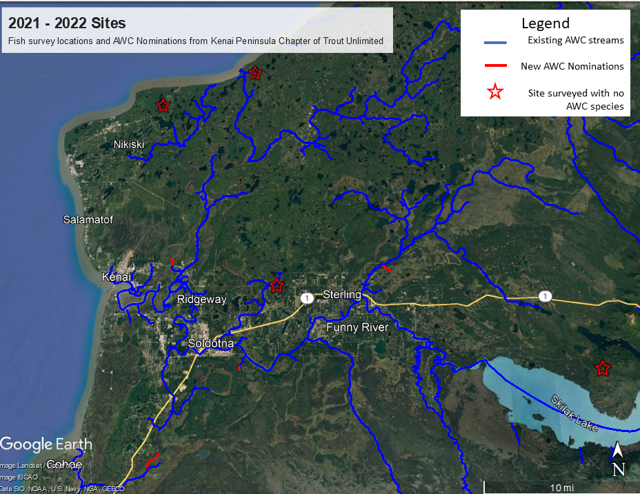
A total length of 3.51 miles of stream segments were included in the nominations from fieldwork supported by KPTU activities. Table 3.4 breaks down each nomination by length. Figure 3.1
| Site | AWC Nomination Length | Unit |
|---|---|---|
| Beaver Creek Trib 1.3 | 0.64 | mile |
| Coal Creek Trib 1 | 1.65 | mile |
| Moose River Trib 1 | 0.87 | mile |
| Funny River Rd Trib 1.1 | 0.35 | mile |

Figure 3.1: Map of AWC nominations.
3.3 Aquatic Resource Permit
Fish capture data was reformatted each fall in to a csv file for submission to ADF&G in fulfillment of the required Aquatic Resource Permit14; available in the online in this project’s GitHub repo15.