Chapter 5 Future Directions
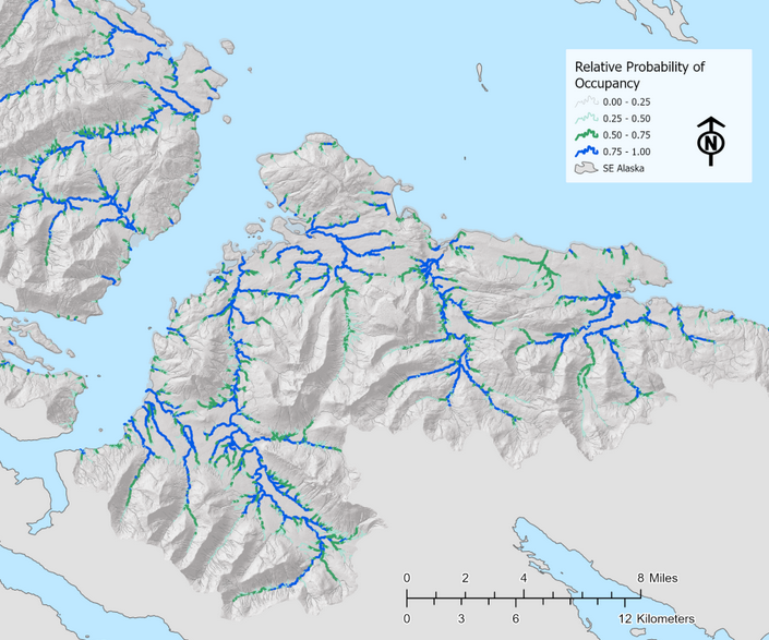
Figure 5.1: Figure from ‘Southeast Alaska Fish Habitat,’ Romey Fisheries and Aquatic Sciences 2021.
The collaboration between the Kenai Peninsula Chapter of Trout Unlimited and Kenai Watershed Forum serves as a compelling example of how to engage volunteers interested in conserving fish habitat with hands-on opportunities. There is great potential to expand and continue the work described in this report, and a great urgency to do so.
The Anadromous Waters nominations generated as a result of this project will play an important role in conserving salmon habitat in the areas we surveyed. The value of educating and engaging volunteer participants is also evident. However in a broader view, the primary take away from this project is highlighting the need to re-frame our long term approach for how to discover, document, and conserve anadromous habitat. Our current methods would continue to yield additional AWC nominations, but at a scale insufficient to keep pace with the need to identify salmon streams in the path of new developments. The potential to accelerate this work and document hundreds of additional anadromous stream miles on the Kenai Peninsula is ready at hand, and much of the initial groundwork has already been completed and is awaiting financial support.
5.1 Rationale for Anadromous Waters Mapping in Alaska
As described in Section 1.2 of this report, current Alaska statute is such that rivers, streams, and lakes throughout Alaska are presumed non-anadromous until otherwise demonstrated, thus the need for the hands-on documentation such as that featured in this project. A failed statewide ballot measure initiative in 2018 would have reversed the baseline presumption of non-anadromy, among other changes to salmon habitat regulations17.
Various state, federal, tribal, private, and non-profit entities have pursued the work of documenting anadromous habitat for decades and contributed to the detail contained within the anadramous waters catalog. Even so, tens of thousands of miles of salmon habitat remain undocumented, including in areas adjacent to developing urban communities. When anadromous habitat is undocumented, proposed development on or near these waters will not trigger the need for a Fish Habitat Permit review from ADF&G, which requires impacts to be evaluated along with possible mitigation requirements such as fish-friendly culverts or enforcement of riparian buffer zones.
This dearth of detailed map information has had consequences particularly in rapidly developing areas. For example, in Summer 2021 a tributary Soldotna Creek was partially excavated and ditched, and was not documented as anadromous until after the fact18. Another prominent example is when in 2008-2010, dozens of anadromous streams were documented and nominated by The Nature Conservancy directly within the proposed footprint of Pebble Mine; waters that had not been documented by mine consultants conducting baseline assessments19,20. Thus the sooner that currently undocumented anadromous waters are documented, the more likely it is that impacts can be properly evaluated and mitigated prior to development.
5.2 Current State of Anadromous Waters Mapping
As described in section 2.1 of this report (Methods: Site Selection), most current fieldwork efforts are prioritized by visually assessing the overlap of stream segments in the Anadromous Waters Catalog and the National Hydrography Database. Communication among regional researchers and managers also helps choose fish survey locations, along with suggestions from the general pubic. Researchers have also used formal oral interviews with traditional knowledge holders to help suggest fish survey locations21.
While all these methods are useful in generating ideas for survey locations, they do not comprise a systematic approach and they are based on incomplete stream network maps. In order for conservation needs to better match the pace of conservation challenges, a more comprehensive approach is needed. In the southern Kenai Peninsula, researchers with Kachemak Bay National Estuarine Research Reserve (KBNERR) successfully applied just such an approach during a study from 2012 (King et al. 2012)22 and added dozens of miles to the AWC from resulting efforts. However, the approach taken by the KBNERR researchers would arguably prove challenging to replicate at broader geographic scales, as it relies on extensive ground truthing of habitat characteristics and flow to produce the predictive model.s
Another similar approach to anadromous habitat mapping is currently being applied in southeast Alaska by the U.S. Forest Service and other partners. Using high resolution stream network maps coupled with fish habitat intrinsic potential models, researchers are able to predict the locations of upper extent of anadromy with 98% accuracy with an average error distance of < 67m23. For more details see the StoryMap from Romey Fisheries and Aquatic Sciences24.
Predicting the locations of upper anadromous extent allows researchers to take a more informed approach to prioritzing their fieldwork of documenting anadromous habitat. Researchers in southcentral Alaska should aspire to emulate the approach described in the preceding StoryMap, focusing particularly on waters outside federally protected areas.
For future long-term efforts to effectively gather field data to be used in AWC nominations, two general research directions are suggested:
Application of higher-resolution stream network maps and habitat modeling approaches, such as NetMap25
Evaluation of “success rates” in prospecting for anadromous sites. E.g., how frequently, when, and where do predictions undocumented anadromous habitat prove correct?
Formal and frequent communication and collaboration among entities conducting anadromous habitat survey work
The combination of these approaches outlines a collaborative “ground-truthing” type approach to AWC mapping, where remote sensing data is used to make predictions that are then refined by field observations. Given the near-perfect rate of predictions thus far using this approach, in the future these maps of stream segments predicted to be anadromous might be used by managers when evaluating environmental impacts and the need for permitting and mitigation – pending continued public education and support and acceptance by regulators.
5.3 Next Steps
To follow though on the recommendations above, a dedicated research project should be developed and executed in collaboration with subject experts. The following steps describe a path forward:
Commission NetMap coverage for the Kenai Peninsula Borough
This task is already partially complete. NetMap was commissioned for the Chugach National Forest in 2017, and Kenai Peninsula coverage extends from Prince William Sound / Turnagain Arm region to the western boundary with Kenai National Wildlife Refuge. The shapefiles are available by contacting Kenai Watershed Forum or Romey Fisheries and Aquatic Sciences.
LiDAR, a geospatial dataset needed to produce the NetMap stream layers, has complete coverage for the Kenai Peninsula Borough region.
A quote for estimated cost was provided to Kenai Watershed Forum from TerrainWorks in Fall 2022.
Develop, communicate, and maintain a prioritized list of fish habitat survey sites shared among multiple agencies
Once a list of locations of predicted Upper Extent of Anadromy is generated using the NetMap layer, regional experts can use their knowledge of local conservation priorities to prioritize which sites should be surveyed first. This step will involve both a GIS based approach for tasks such as identifying parcel ownership status where sites are located, as well as a consensus/discussion based approach to apply knowledge of local conservation priorities and planning efforts.
Site survey responsibilities will be assigned to participating organizations. Once complete, preliminary results will be recorded in a shared database to minimize redundant site visits.
Recruit and train participants from agency employees and volunteers
Entities known to currently be engaged in the work of AWC nominations in the Kenai Peninsula region include the following, but are not limited to:
Alaska Department of Fish and Game Habitat Division
Kenai Soil and Water Conservation District
U.S. Fish and Wildlife Service
Kenai Watershed Forum
Kachemak Bay National Estuarine Research Reserve
Kenai Peninsula Chapter of Trout Unlimited
University of Alaska
Training sessions would be offered to encourage participation from the general public
Employing a user-friendly, seamless method of data collection will be critical to implementing this project on a larger scale. ADF&G requires that AWC nominations are supervised by a “qualified biologist,” thus careful and systematic review of nomination data prior to submission will be essential. Use of a custom-designed ESRI Survey123 app is likely the most appropriate choice for this task. The smartphone app “Fish Map App26” developed by the Indiginous Sentinals Network also shows potential to be highly useful in this process; though currently the app is not designed to record some essential information such as gear effort.
A high degree of location accuracy (<1m) is required for ground-truthing NetMap data. Expensive options such as Trimble hand held devices may be inaccessible, thus it is suggested to train participants to use bluetooth accessory receivers (e.g. Bad Elf GNSS Surveyor) when recording coordinates.
A suggested initial approach is to use the already-existing NetMap layer covering the Chugach National Forest region in the process described above. Pending successful results and AWC nominations, the project as described above should be commissioned and executed at the scale of the entire Kenai Peninsula Borough region. Many other regions of Alaska have already had synthetic stream networks developed and mapped. Following the success of the work proposed above, the approach would be able to be replicated state-wide.
5.4 Final Words
While this report shows how much has been accomplished in documenting local salmon habitat, it is clearer than ever how much remains to be accomplished. We are grateful for the help and support of the dozens of volunteers involved with making this project happen and we look forward to continuing our efforts together.
https://ballotpedia.org/Alaska_Ballot_Measure_1,_Salmon_Habitat_Protections_and_Permits_Initiative_(2018)↩︎
https://bookdown.org/kwfwqx/awc_expansion/discussion.html#highlight-soldotna-creek-tributary↩︎
http://www.pebblescience.org/pdfs/FishSurveysinNushagak%20and%20Kvichakheadwaters.pdf↩︎
https://www.adn.com/alaska-news/article/salmon-documented-streams-top-pebble-prospect/2011/04/27/↩︎
Personal communication with Duncan Green, Alaska Department of Fish and Game, February 21, 2022↩︎
https://www.journals.uchicago.edu/doi/abs/10.1899/11-109.1↩︎
https://paperpile.com/app/p/e21bfd9e-9b5a-0237-ad38-12b73fbdccbb↩︎
https://storymaps.arcgis.com/stories/6b3949e1ebcd44c6a531d13f038807c5↩︎