1 Current information on Raphia taedigera distribution
The first step towards addressing the connectivity of patches of Raphia taedigera swamps is to determine the geographic distribution of Raphia taedigera swamps. For this objective there are three main sources of information:
Digitizing published maps were Raphia taedigera (Yolillales) have been identified
Query to digital biodiversity databases (GBIF)
Records from published literature
Using this sources, I intend to gather the most information on the distribution of Raphia taedigera.
1.1 Data from published maps
Raphia taedigera is known to be distributed in Central America, some parts in the carribbean coast of Colombia and in the Amazon river delta in Brazil (Sandi et al. 2013). For Costa Rica and Nicaragua, the distribution, surface and protected area of Raphia taedigera palm swamps have been assessed (Sandi et al. 2013). This maps were constructed by delineating cartographic maps at 1:50 000 scale. Catographic maps for Costa Rica comes from the the IGN (Instituto Geografico Nacional de Costa Rica) and were rectified in 1982. Maps were projected to CRTM 05 and WGS-84. For Nicaragua, maps were projected using UTM-Z17 and WGS 84 and cartographic maps come from INETER (Instituto Nicaraguense de Estudios Territoriales).
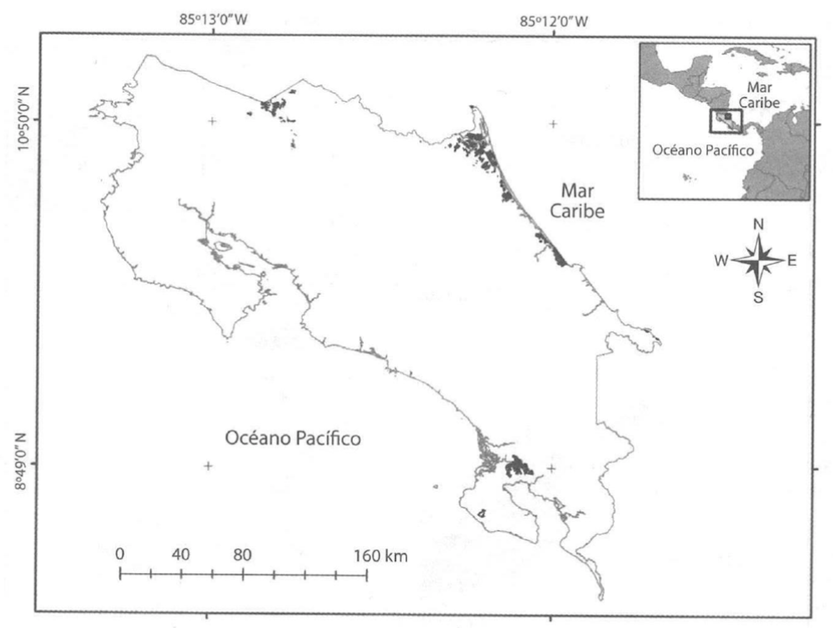
Figure 1.1: Raphia taedigera swamp (Yolillal) distributions for Costa Rica, Yolillal distribution was estimated by georeferenciating cartographic maps at 1:50000
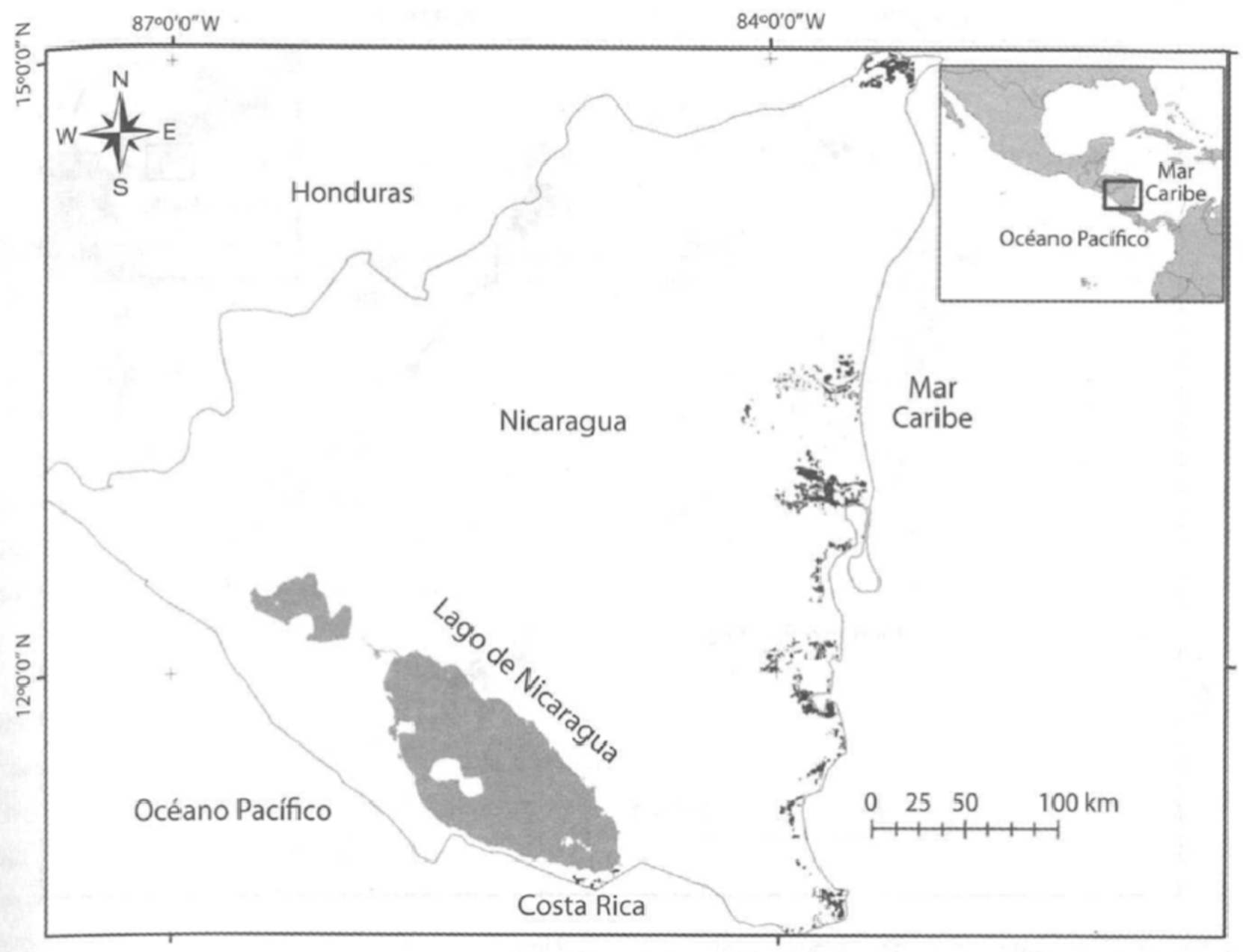
Figure 1.2: Raphia taedigera swamp (Yolillal) distributions for Nicaragua, Yolillal distribution was estimated by georeferenciating cartographic maps at 1:50000
Yolillales distributions for Costa Rica and Nicaragua presented in Sandi et al. (2013) were digitallized from a scanned picture from the original publication. The digitalization and georeferencing was done manually in ArcGIS 10.4 at a 1:400 000 scale using the EuroSTAT World Country polygons as a basemap.
## OGR data source with driver: ESRI Shapefile
## Source: "zipfolder/CostaRicaSwamp.shp", layer: "CostaRicaSwamp"
## with 18 features
## It has 1 fields## OGR data source with driver: ESRI Shapefile
## Source: "zipfolder/NicaraguaSwamp.shp", layer: "NicaraguaSwamp"
## with 66 features
## It has 1 fields## OGR data source with driver: ESRI Shapefile
## Source: "zipfolder/Eurostat_World_Country_Polygons_2010.shp", layer: "Eurostat_World_Country_Polygons_2010"
## with 8 features
## It has 3 fieldsFigure 1.3: Digitalization and georeferenciation results of Sandi 2013 distribution maps for Raphia taedigera in Costa Rica (brown) and Nicaragua (green)
1.2 Adding records from GBIF
Additional records of Raphia taedigera can be found in the GBIF page.
Using the bdvis package. see Barve and Otegui (2016).
# Download Raphia taedigera records
RaphiaTaedigera <- occ_search(scientificName = "Raphia taedigera", limit = 10000)
# Fix the field names and add extra values
Raphia <- format_bdvis(RaphiaTaedigera$data, "rgbif")General visualization of downloaded data
# Create gridded species density map
region = c("Costa Rica", "Nicaragua", "Panama", "Colombia", "Brazil")
bounding = c(-97.73,-36.73,-31.28,21.45)
mapgrid(Raphia,
region = region,
ptype = "records",
collow = "#7fd9d7",
colhigh = "red",
title = "GBIF occurrences of Raphia taedigera",
bbox = bounding)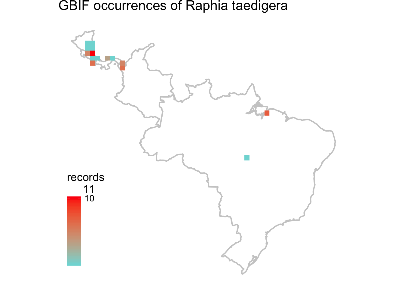
Figure 1.4: Records of Raphia taedigera present in the Global Biodiversity Information Facility
General summary of results from GBIF query:
Total no of records = 90
Temporal coverage… Date range of the records from 1826-01-01 to 2014-02-19
Taxonomic coverage… No of Families : 0 No of Genus : 0 No of Species : 1
Spatial coverage … Bounding box of records -21.7944 , -84.8978 - 12.8614 , 0 Degree celles covered : 18 % degree cells covered : 0.630252100840336
Adding GBIF results to known distribution of Raphia taedigera
Figure 1.5: Known distribution of Raphia taedigera, data includes Sandi et al. 2013 digitized maps (Continous distributions) and GBIF records (Single points). For the GBIF data hover each location point to visualize the date of collection (when available), click in the markers to reveal detailed locality information (when available)